IMAGES TAKEN NEAR TO
Albion Road, LONDON, N16 9JU
Introduction
This page details the photographs taken nearby to Albion Road, N16 9JU by members of the Geograph project.
The Geograph project started in 2005 with the aim of publishing, organising and preserving representative images for every square kilometre of Great Britain, Ireland and the Isle of Man.

There are currently over 7.5m images from over14,400 individuals and you can help contribute to the project by visiting https://www.geograph.org.uk
Image Map
Images are licensed for reuse under creativecommons.org/licenses/by-sa/2.0
Notes
- Clicking on the map will re-center to the selected point.
- The higher the marker number, the further away the image location is from the centre of the postcode.
Image Listing (248 Images Found)
Images are licensed for reuse under creativecommons.org/licenses/by-sa/2.0
Image
Details
Distance
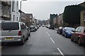
1
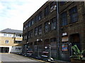
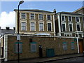
Old factory in Church Walk
Church Walk no longer goes through to Church Street and, heading north, it ends here in a cul-de-sac beside what appears to be a derelict factory. Beyond it a footpath turns right into Albion Road.
Image: © Natasha Ceridwen de Chroustchoff
Taken: 27 Jul 2009
0.02 miles
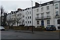
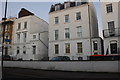
3
174 - 8 Albion Rd
Grade II listed. http://www.britishlistedbuildings.co.uk/101079861-174-and-178-albion-road-n16-clissold-ward
Image: © N Chadwick
Taken: 10 Feb 2017
0.03 miles
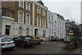
6
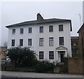
No.147 and No.149, Albion Road, Stoke Newington
2 Grade II listed houses on Albion Road.
See http://www.britishlistedbuildings.co.uk/en-426482-147-and-149-albion-road-n16-greater-lond for more details about the buildings.
Image: © David Anstiss
Taken: 3 Feb 2013
0.04 miles
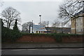
9
Valide Sultan Mosque
This Turkish mosque (behind the wall) and cultural centre was built in 1992 and occupies a triangular site at 1a Clissold Road that was formerly the site of stables belonging a large house that is now gone. Clissold Road itself was constructed in the 1880s to house prosperous families, and although the end house here looks original it is in fact a replica designed to match its neighbours.
Image: © Natasha Ceridwen de Chroustchoff
Taken: 27 Jul 2009
0.08 miles