IMAGES TAKEN NEAR TO
Shakspeare Walk, LONDON, N16 8TL
Introduction
This page details the photographs taken nearby to Shakspeare Walk, N16 8TL by members of the Geograph project.
The Geograph project started in 2005 with the aim of publishing, organising and preserving representative images for every square kilometre of Great Britain, Ireland and the Isle of Man.

There are currently over 7.5m images from over14,400 individuals and you can help contribute to the project by visiting https://www.geograph.org.uk
Image Map
Images are licensed for reuse under creativecommons.org/licenses/by-sa/2.0
Notes
- Clicking on the map will re-center to the selected point.
- The higher the marker number, the further away the image location is from the centre of the postcode.
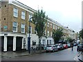
Image Listing (157 Images Found)
Images are licensed for reuse under creativecommons.org/licenses/by-sa/2.0
Image
Details
Distance
1
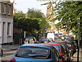
Howard Road, London N16 - St Matthias church
Saint Matthias church in the distance, looking down Howard Road from Albion Road.
Image: © Chris Sitton
Taken: 17 Jun 2007
0.08 miles
2
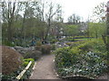
Butterfield Green, Stoke Newington (2)
A little park in the middle of a densely populated area. This is a rockery area.
Image: © Danny P Robinson
Taken: 8 Apr 2007
0.08 miles
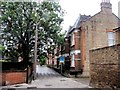
4
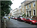
Houses in Church Walk
An attractive terrace of Edwardian houses tucked away in this section of Church Walk.
Image: © Natasha Ceridwen de Chroustchoff
Taken: 27 Jul 2009
0.09 miles
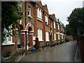
5
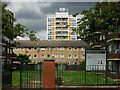
Hewling Estate, Stoke Newington
Rain clouds gather over these blocks of flats on the north side of Matthias Road. The two blocks facing each other across the green form the Hewling estate and were constructed in the late 1930s to replace an area of poor quality housing. Hewling House is to the left, Matthias House to the right; there were originally three blocks but the third was destroyed by a Second World War bomb. The tall block in the background is Chaucer House, part of the Milton Gardens Estate. More details of the history of this area are available here: http://www.locallocalhistory.co.uk/municipal-housing/howard/index.htm
Image: © Stephen McKay
Taken: 15 May 2009
0.09 miles
6
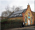
Wordsworth Road Baptist Chapel, Stoke Newington
Built in 1894. Locally listed. Description at this http://hackneybuildings.org/items/show/19402
Image: © Jim Osley
Taken: 11 Jan 2017
0.09 miles
7
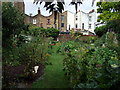
Back gardens along Church Walk
Productive gardens rich with flowers and veg were one of the pleasures found along this stretch of Church Walk. Houses beyond front Albion Road.
Image: © Natasha Ceridwen de Chroustchoff
Taken: 27 Jul 2009
0.09 miles
10

Butterfield Green, Stoke Newington (1)
A little park in the middle of a densely populated area. Picture taken from the Bandstand.
Image: © Danny P Robinson
Taken: 8 Apr 2007
0.10 miles