IMAGES TAKEN NEAR TO
Boleyn Road, LONDON, N16 8JX
Introduction
This page details the photographs taken nearby to Boleyn Road, N16 8JX by members of the Geograph project.
The Geograph project started in 2005 with the aim of publishing, organising and preserving representative images for every square kilometre of Great Britain, Ireland and the Isle of Man.

There are currently over 7.5m images from over14,400 individuals and you can help contribute to the project by visiting https://www.geograph.org.uk
Image Map
Images are licensed for reuse under creativecommons.org/licenses/by-sa/2.0
Notes
- Clicking on the map will re-center to the selected point.
- The higher the marker number, the further away the image location is from the centre of the postcode.
Image Listing (281 Images Found)
Images are licensed for reuse under creativecommons.org/licenses/by-sa/2.0
Image
Details
Distance
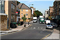
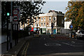
2

Dalston - Jude Street from Bradbrury Street
Image: © Peter Whatley
Taken: 11 Apr 2011
0.04 miles
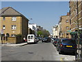

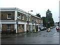
6
Dalston: St. Jude Street
The spire visible at the far end belongs to St. Jude and St. Paul's Church.
Image: © Dr Neil Clifton
Taken: 7 Oct 2010
0.05 miles
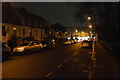
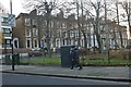
10

St Judes Street Garden
This small play area and green space beyond is next to the London Overground line between Canonbury and Dalston Kingsland. The railway is just beyond the wall on the right.
Image: © Marathon
Taken: 19 Jun 2013
0.05 miles