IMAGES TAKEN NEAR TO
Bailey Place, LONDON, N16 8BA
Introduction
This page details the photographs taken nearby to Bailey Place, N16 8BA by members of the Geograph project.
The Geograph project started in 2005 with the aim of publishing, organising and preserving representative images for every square kilometre of Great Britain, Ireland and the Isle of Man.

There are currently over 7.5m images from over14,400 individuals and you can help contribute to the project by visiting https://www.geograph.org.uk
Image Map
Images are licensed for reuse under creativecommons.org/licenses/by-sa/2.0
Notes
- Clicking on the map will re-center to the selected point.
- The higher the marker number, the further away the image location is from the centre of the postcode.
Image Listing (275 Images Found)
Images are licensed for reuse under creativecommons.org/licenses/by-sa/2.0
Image
Details
Distance

2

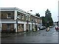
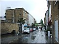
Dalston - Jude Street from Bradbrury Street
Image: © Peter Whatley
Taken: 11 Apr 2011
0.01 miles
3
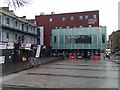
Square in front of Dalston Culture House
Image: © David Martin
Taken: 8 May 2014
0.02 miles
6
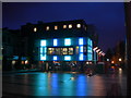
Vortex Jazz Club
On Gillett Street, N16.
Image: © Danny P Robinson
Taken: 20 Feb 2007
0.04 miles

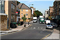
9

St Judes Street Garden
This small play area and green space beyond is next to the London Overground line between Canonbury and Dalston Kingsland. The railway is just beyond the wall on the right.
Image: © Marathon
Taken: 19 Jun 2013
0.05 miles
10
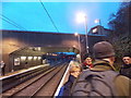
View west from the eastbound platform at Dalston Kingsland station
Looking west. Note the abundance of red signals in the background.
Image: © Robert Lamb
Taken: 3 Feb 2013
0.05 miles