IMAGES TAKEN NEAR TO
Farleigh Road, LONDON, N16 7TQ
Introduction
This page details the photographs taken nearby to Farleigh Road, N16 7TQ by members of the Geograph project.
The Geograph project started in 2005 with the aim of publishing, organising and preserving representative images for every square kilometre of Great Britain, Ireland and the Isle of Man.

There are currently over 7.5m images from over14,400 individuals and you can help contribute to the project by visiting https://www.geograph.org.uk
Image Map
Images are licensed for reuse under creativecommons.org/licenses/by-sa/2.0
Notes
- Clicking on the map will re-center to the selected point.
- The higher the marker number, the further away the image location is from the centre of the postcode.
Image Listing (64 Images Found)
Images are licensed for reuse under creativecommons.org/licenses/by-sa/2.0
Image
Details
Distance
1
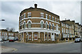
Old pub
This building on the corner of Amhurst Road and Foulden Road looks as if it could well have been a pub once, and indeed it was. It is shown as the Farleigh Hotel (P.H.) on old large scale maps.
Image: © Robin Webster
Taken: 5 Feb 2011
0.07 miles
2
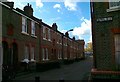
Seal Street
In the early 16th century Sir John Heron, reputedly the richest man in Hackney, owned a large estate centred on a manor house in Shacklewell – its site now covered by shops. Several villas for gentlemen were built during the course of the 18th century, interspersed with lesser properties for tradesmen, two pubs and a dairy on the south side of the village green. Side roads subsequently proliferated, many lined with cramped terraces, but Shacklewell remained an isolated settlement until Hackney expanded outwards to meet it in the mid-19th century. Perch, Seal and April Streets were laid out in the early 1880s with good quality terraces for working people, and Shacklewell Green was taken into public ownership.
Text taken from http://hidden-london.com/gazetteer/shacklewell/
Image: © Henry Creed
Taken: 5 Nov 2012
0.12 miles
4
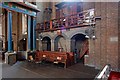
St Barnabas, Shacklewell Row, Dalston - Chancel & organ
Image: © John Salmon
Taken: 31 Jul 2011
0.14 miles
5

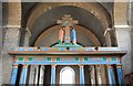
St Barnabas, Shacklewell Row, Dalston - Sanctuary
Image: © John Salmon
Taken: 31 Jul 2011
0.14 miles
6
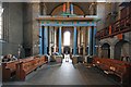
St Barnabas, Shacklewell Row, Dalston - West end
Image: © John Salmon
Taken: 31 Jul 2011
0.15 miles
7

St Barnabas, Shacklewell Row, Dalston - Memorial WWI
Image: © John Salmon
Taken: 31 Jul 2011
0.15 miles
8
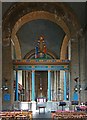
St Barnabas, Shacklewell Row, Dalston - Chancel screen
Image: © John Salmon
Taken: 31 Jul 2011
0.15 miles
9
St Barnabas, Shacklewell Row, Dalston - East end
Image: © John Salmon
Taken: 31 Jul 2011
0.15 miles
10
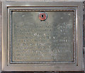
St Barnabas, Shacklewell Row, Dalston - Memorial WWI
Image: © John Salmon
Taken: 31 Jul 2011
0.15 miles