IMAGES TAKEN NEAR TO
Station Approach, LONDON, N16 6YA
Introduction
This page details the photographs taken nearby to Station Approach, N16 6YA by members of the Geograph project.
The Geograph project started in 2005 with the aim of publishing, organising and preserving representative images for every square kilometre of Great Britain, Ireland and the Isle of Man.

There are currently over 7.5m images from over14,400 individuals and you can help contribute to the project by visiting https://www.geograph.org.uk
Image Map
Images are licensed for reuse under creativecommons.org/licenses/by-sa/2.0
Notes
- Clicking on the map will re-center to the selected point.
- The higher the marker number, the further away the image location is from the centre of the postcode.
Image Listing (147 Images Found)
Images are licensed for reuse under creativecommons.org/licenses/by-sa/2.0
Image
Details
Distance
1
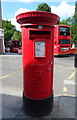
Elizabeth II postbox, Stoke Newington Railway Station
Postbox No. N16 21.
See Image] for context.
Image: © JThomas
Taken: 6 Jul 2019
0.01 miles
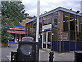
2
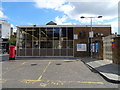
Stoke Newington Railway Station
Showing position of Postbox No. N16 21.
See Image] for postbox.
Image: © JThomas
Taken: 6 Jul 2019
0.01 miles
3
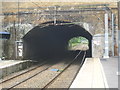
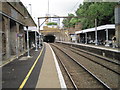
Stoke Newington station
The line from Bethnal Green station to Stoke Newington station was opened by the Great Eastern Railway on 27th May 1872. This had intermediate stations very closely spaced: at Cambridge Heath, London Fields, Hackney Downs, Rectory Road and Stoke Newington. The route was continued on to Lower Edmonton on 22nd July 1872 and to Edmonton Junction on 1st August 1872.
In his book 'London's Local Railways' (1978) from which the above information was obtained, Alan A Jackson described a visit to the line in 1955: "The dreary stations almost untouched, their soot-stained brickwork and cavernous stairways giving shelter to the ghosts of corduroy-trousered workmen and consumptive clerks clutching their cheap tickets." The brickwork has been cleaned up but much of the rest of the description still rings true.
This view looks down the line under the bridge carrying Stamford Hill over the line.
Image: © Marathon
Taken: 19 Jun 2013
0.01 miles
4
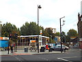
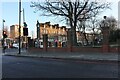
Stoke Newington station
This low-rise building is Stoke Newington station. Since 2015, trains from this station have been operated as part of the London Overground network.
Image: © Malc McDonald
Taken: 8 Oct 2016
0.01 miles


9
Stoke Newington railway station, Greater London
Opened in 1872 by the Great Eastern Railway on its line from London Liverpool Street to Broxbourne. View north west towards Stamford Hill and Broxbourne.
Image: © Nigel Thompson
Taken: 3 Jul 2012
0.03 miles
10
Manor Road at the junction of Stamford Hill
Stoke Newington Station is on the left.
Image: © David Howard
Taken: 22 Jan 2023
0.03 miles