IMAGES TAKEN NEAR TO
Queen Elizabeths Walk, LONDON, N16 5UG
Introduction
This page details the photographs taken nearby to Queen Elizabeths Walk, N16 5UG by members of the Geograph project.
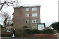
The Geograph project started in 2005 with the aim of publishing, organising and preserving representative images for every square kilometre of Great Britain, Ireland and the Isle of Man.

There are currently over 7.5m images from over14,400 individuals and you can help contribute to the project by visiting https://www.geograph.org.uk
Image Map
Images are licensed for reuse under creativecommons.org/licenses/by-sa/2.0
Notes
- Clicking on the map will re-center to the selected point.
- The higher the marker number, the further away the image location is from the centre of the postcode.
Image Listing (167 Images Found)
Images are licensed for reuse under creativecommons.org/licenses/by-sa/2.0
Image
Details
Distance
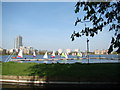
1
View of Tower 42 and the Shard from the path through the Woodberry Down Estate
Looking south-southeast.
Image: © Robert Lamb
Taken: 15 Jun 2013
0.06 miles
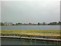
2

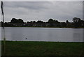
Woodberry Wetlands
Looking across the West Reservoir.
Image: © Trevor Harris
Taken: 16 Jan 2022
0.06 miles
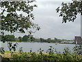
3
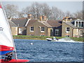
View of the North London Association Yachts on the West Reservoir and three towerblocks on Bethune Road
Looking north-northeast.
Image: © Robert Lamb
Taken: 29 Mar 2014
0.06 miles
4

View of Lincoln Court, Bethune Road and flats on Lordship Road from the New River Walkway
Looking north-northeast.
Image: © Robert Lamb
Taken: 29 Mar 2014
0.07 miles
5
A speedboat on the West Reservoir
Looking east-southeast.
Image: © Robert Lamb
Taken: 29 Mar 2014
0.08 miles
6
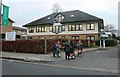
The Bearsted Centre, Stamford Hill
Oddly the sign spells it Bearstead but it isn't. Built on the site of an old Jewish hospital and now a Jewish care home. http://www.ezitis.myzen.co.uk/bearstedmemorial.html
Image: © David Howard
Taken: 26 Jan 2022
0.10 miles
7
View of houses on Lordship Road from the New River Walkway
Looking north-northeast.
Image: © Robert Lamb
Taken: 15 Jun 2013
0.12 miles
8
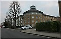
Lordship Road at the junction of Schonfield Square
Image: © David Howard
Taken: 26 Jan 2022
0.12 miles