IMAGES TAKEN NEAR TO
Amhurst Park, LONDON, N16 5AW
Introduction
This page details the photographs taken nearby to Amhurst Park, N16 5AW by members of the Geograph project.
The Geograph project started in 2005 with the aim of publishing, organising and preserving representative images for every square kilometre of Great Britain, Ireland and the Isle of Man.

There are currently over 7.5m images from over14,400 individuals and you can help contribute to the project by visiting https://www.geograph.org.uk
Image Map
Images are licensed for reuse under creativecommons.org/licenses/by-sa/2.0
Notes
- Clicking on the map will re-center to the selected point.
- The higher the marker number, the further away the image location is from the centre of the postcode.
Image Listing (138 Images Found)
Images are licensed for reuse under creativecommons.org/licenses/by-sa/2.0
Image
Details
Distance
1
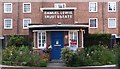
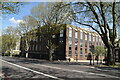
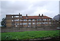
Estate manager's office, Samuel Lewis Trust Estate
The estate was built 1938-1939.
Image: © Jim Osley
Taken: 13 Aug 2014
0.06 miles
3
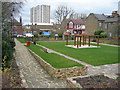
Manchester Gardens, South Tottenham
A small park at the corner of Seven Sisters Road and Manchester Road.
Image: © Danny P Robinson
Taken: 13 Mar 2009
0.10 miles
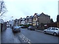
4
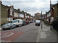
Heysham Road, N15
Viewed from Seven Sisters Road.
Image: © Danny P Robinson
Taken: 13 Mar 2009
0.10 miles
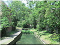
5
The New River west of Bethune Road, N4 (4)
See Image
Image: © Mike Quinn
Taken: 18 Jun 2015
0.12 miles
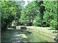
7
The New River west of Bethune Road, N4 (2)
Image: © Mike Quinn
Taken: 18 Jun 2015
0.12 miles
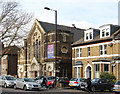
9
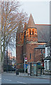
South Tottenham : Woodberry Down Baptist Church
Built 1882-1883 to a design by architects Paull & Bonella.
Image: © Jim Osley
Taken: 4 Jan 2019
0.13 miles