IMAGES TAKEN NEAR TO
Balmes Road, LONDON, N1 5SW
Introduction
This page details the photographs taken nearby to Balmes Road, N1 5SW by members of the Geograph project.
The Geograph project started in 2005 with the aim of publishing, organising and preserving representative images for every square kilometre of Great Britain, Ireland and the Isle of Man.

There are currently over 7.5m images from over14,400 individuals and you can help contribute to the project by visiting https://www.geograph.org.uk
Image Map
Images are licensed for reuse under creativecommons.org/licenses/by-sa/2.0
Notes
- Clicking on the map will re-center to the selected point.
- The higher the marker number, the further away the image location is from the centre of the postcode.
Image Listing (226 Images Found)
Images are licensed for reuse under creativecommons.org/licenses/by-sa/2.0
Image
Details
Distance
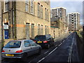
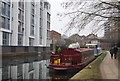
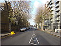
3
Canal Walk
Looking along Regent's Canal towards Bridport Place bridge ahead.
Image: © DS Pugh
Taken: 5 Apr 2016
0.03 miles
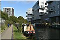
6
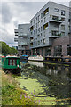
Acton Apartments
Apartment block overlooking Regent's Canal.
Image: © Ian Capper
Taken: 13 Jul 2019
0.04 miles
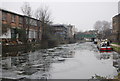
8
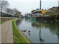
Canada Geese, Regent's Canal
Between bridges 42 and 43.
Image: © Robin Webster
Taken: 22 Jan 2011
0.05 miles
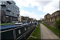
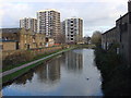
10
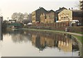
Buildings by Regent's Canal
The buildings on the right can be seen on the left of Image, taken from the Rosemary Branch Bridge (left). Left of centre is Thomas Briggs (tentmakers) Victorian factory.
Image: © Derek Harper
Taken: 7 Jan 2011
0.05 miles