IMAGES TAKEN NEAR TO
Mill Row, LONDON, N1 5RL
Introduction
This page details the photographs taken nearby to Mill Row, N1 5RL by members of the Geograph project.
The Geograph project started in 2005 with the aim of publishing, organising and preserving representative images for every square kilometre of Great Britain, Ireland and the Isle of Man.

There are currently over 7.5m images from over14,400 individuals and you can help contribute to the project by visiting https://www.geograph.org.uk
Image Map
Images are licensed for reuse under creativecommons.org/licenses/by-sa/2.0
Notes
- Clicking on the map will re-center to the selected point.
- The higher the marker number, the further away the image location is from the centre of the postcode.
Image Listing (356 Images Found)
Images are licensed for reuse under creativecommons.org/licenses/by-sa/2.0
Image
Details
Distance
4
Last orders have been called
The former King's Head on Kingsland Road.
Image: © John H Darch
Taken: 20 May 2016
0.02 miles
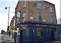
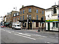
8
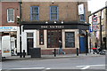
Kingsland Road: The 'Victory'
This pub was built in 1839, and after a recent period of closure it has reopened. It is on the west side of Kingsland Road, not far south of the Regent's Canal.
Image: © Dr Neil Clifton
Taken: 9 Mar 2011
0.03 miles
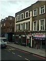
9
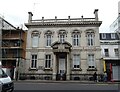
Former Haggerston Library, Kingsland Road
Converted to residential accommodation - Grade II listed.
Image: © JThomas
Taken: 22 Aug 2022
0.03 miles
10
Haggerston: The 'Hobby Horse'
At the junction of Kingsland Road with Orsman Road
Image: © Dr Neil Clifton
Taken: 25 Feb 2010
0.03 miles