IMAGES TAKEN NEAR TO
New Era Estate, LONDON, N1 5RH
Introduction
This page details the photographs taken nearby to New Era Estate, N1 5RH by members of the Geograph project.
The Geograph project started in 2005 with the aim of publishing, organising and preserving representative images for every square kilometre of Great Britain, Ireland and the Isle of Man.

There are currently over 7.5m images from over14,400 individuals and you can help contribute to the project by visiting https://www.geograph.org.uk
Image Map
Images are licensed for reuse under creativecommons.org/licenses/by-sa/2.0
Notes
- Clicking on the map will re-center to the selected point.
- The higher the marker number, the further away the image location is from the centre of the postcode.
Image Listing (319 Images Found)
Images are licensed for reuse under creativecommons.org/licenses/by-sa/2.0
Image
Details
Distance
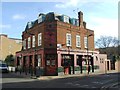
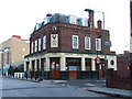
1
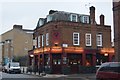
The Stags Head
Grade II listed. http://www.britishlistedbuildings.co.uk/101427212-the-stags-head-public-house-hoxton-hoxton-east-shoreditch-ward
Image: © N Chadwick
Taken: 10 Feb 2017
0.01 miles
2
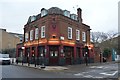
The Stags Head
Grade II listed. http://www.britishlistedbuildings.co.uk/101427212-the-stags-head-public-house-hoxton-hoxton-east-shoreditch-ward
Image: © N Chadwick
Taken: 10 Feb 2017
0.01 miles
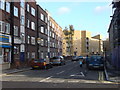
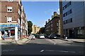
7
Orsman Street at the junction of Whitmore Road
Image: © David Howard
Taken: 18 Dec 2021
0.04 miles
9

Public Artwork on the centre of a roundabout
For an image of the roundabout Image
Image: © Oxyman
Taken: 25 Nov 2008
0.05 miles