IMAGES TAKEN NEAR TO
Colville Estate, LONDON, N1 5PR
Introduction
This page details the photographs taken nearby to Colville Estate, N1 5PR by members of the Geograph project.
The Geograph project started in 2005 with the aim of publishing, organising and preserving representative images for every square kilometre of Great Britain, Ireland and the Isle of Man.

There are currently over 7.5m images from over14,400 individuals and you can help contribute to the project by visiting https://www.geograph.org.uk
Image Map
Images are licensed for reuse under creativecommons.org/licenses/by-sa/2.0
Notes
- Clicking on the map will re-center to the selected point.
- The higher the marker number, the further away the image location is from the centre of the postcode.
Image Listing (300 Images Found)
Images are licensed for reuse under creativecommons.org/licenses/by-sa/2.0
Image
Details
Distance
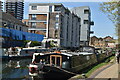
1
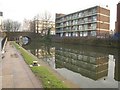
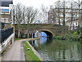
Kenning House
The block of 16 flats overlooks the Regent's Canal beside Whitmore Bridge.
Image: © Derek Harper
Taken: 7 Jan 2011
0.01 miles
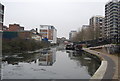
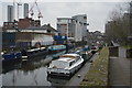
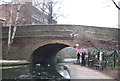
10
Whitmore Bridge, bridge 43, Regent's Canal
Whitmore Road crosses.
Image: © Robin Webster
Taken: 22 Jan 2011
0.03 miles