IMAGES TAKEN NEAR TO
Phillipp Street, LONDON, N1 5PA
Introduction
This page details the photographs taken nearby to Phillipp Street, N1 5PA by members of the Geograph project.
The Geograph project started in 2005 with the aim of publishing, organising and preserving representative images for every square kilometre of Great Britain, Ireland and the Isle of Man.

There are currently over 7.5m images from over14,400 individuals and you can help contribute to the project by visiting https://www.geograph.org.uk
Image Map
Images are licensed for reuse under creativecommons.org/licenses/by-sa/2.0
Notes
- Clicking on the map will re-center to the selected point.
- The higher the marker number, the further away the image location is from the centre of the postcode.
Image Listing (314 Images Found)
Images are licensed for reuse under creativecommons.org/licenses/by-sa/2.0
Image
Details
Distance

2
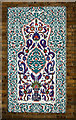
Decorative tilework, Suleymaniye Mosque, Kingsland Road
Image: © Jim Osley
Taken: 18 Feb 2012
0.04 miles
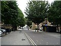
7
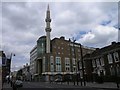
Haggerston Mosque
Haggerston Mosque, with its distinctive minaret.
Image: © Hywel Williams
Taken: 30 Apr 2006
0.07 miles
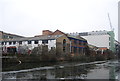
8

Regent's Canal, Hoxton
Looking west along the Regent's Canal at Kingsland Basin, Hoxton. The basin is a branch off to the right - the walkers are about to cross the bridge over the basin entrance.
Image: © Pierre Terre
Taken: 7 May 2005
0.07 miles
9

Kingsland Basin Entrance
Regent's Canal towpath bridge over the entrance to Kingsland Basin
Image: © Pierre Terre
Taken: 7 May 2005
0.07 miles
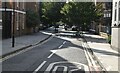
10

Regents Canal, looking west from Kingsland Bridge
The towpath is on the north side here and it can be seen to rise slightly at what was once the entrance to Kingsland Basin on the right. Whitmore Bridge can be seen in the far distance.
Image: © Dr Neil Clifton
Taken: 19 Jul 2007
0.07 miles