IMAGES TAKEN NEAR TO
Nuttall Street, LONDON, N1 5LZ
Introduction
This page details the photographs taken nearby to Nuttall Street, N1 5LZ by members of the Geograph project.
The Geograph project started in 2005 with the aim of publishing, organising and preserving representative images for every square kilometre of Great Britain, Ireland and the Isle of Man.

There are currently over 7.5m images from over14,400 individuals and you can help contribute to the project by visiting https://www.geograph.org.uk
Image Map (Loading...)


Getting Data...Please wait
Leaflet Map data © OpenStreetMap
Images are licensed for reuse under creativecommons.org/licenses/by-sa/2.0
Notes
- Clicking on the map will re-center to the selected point.
- The higher the marker number, the further away the image location is from the centre of the postcode.
Image Listing (409 Images Found)
Images are licensed for reuse under creativecommons.org/licenses/by-sa/2.0
Image
Details
Distance
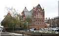
1
Christ Apostolic Church, Kingsland Road, Hoxton
Used to be St Columba
Image: © John Salmon
Taken: 5 Oct 2011
0.02 miles
2
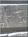
Cut bench mark on St Leonard's Hospital
Barely visible because of paint. See http://www.bench-marks.org.uk/bm43792 for details.
Image: © Brian Westlake
Taken: 26 May 2012
0.02 miles
3
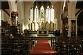
St Anne with St Columba, Hoxton Road, Hoxton - East end
Image: © John Salmon
Taken: 5 Oct 2011
0.02 miles
4
Christ Apostolic Church, Kingsland Road, Hoxton
Used to be St Columba
Image: © John Salmon
Taken: 5 Oct 2011
0.03 miles
5
St. Columba's Church, Kingsland Road, London
Now this has become the 'Christ Apostolic Church'.
Image: © Dr Neil Clifton
Taken: 19 Jul 2007
0.03 miles
7
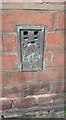
Ordnance Survey Flush Bracket (S0543)
This OS Flush Bracket can be found on the east face of St Columba's Church. It marks a point 19.834m above mean sea level.
Image: © Adrian Dust
Taken: 16 Aug 2016
0.03 miles
8
Haggerston: St. Columba's Church, Kingsland Road
This large church was built in 1867-1869. It became disused by the Church of England in 1979, but has been taken over by the 'Christ Apostolic Church'.
Image: © Dr Neil Clifton
Taken: 9 Mar 2011
0.04 miles
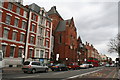
9
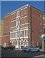
Hoxton : St Leonard Office for the Relief of the Poor
Grade II listed facade: "The other public face of the former workhouse is the facade to the Relief Office fronting Hoxton Street (further to the west). Like the main front this is red brick with Portland stone dressings but the style is Italianate. It has round arched windows on the ground floor and a broken pediment centrepiece above the quoined first floor windows; the upper floors are plainer. The string courses are painted with 'St Leonard / 1863 / Shoreditch / Offices for the Relief of the Poor' in capital letters. Only the façade of the original building survives." - historicengland.org.uk/listing/the-list/list-entry/1393325.
Image: © Jim Osley
Taken: 22 Apr 2020
0.04 miles
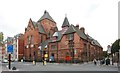
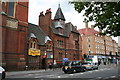
10
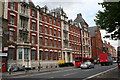
St Leonard's Hospital, Kingsland Road, London
This building started as a workhouse, became a hospital and is now a care home.
Image: © Dr Neil Clifton
Taken: 19 Jul 2007
0.04 miles