IMAGES TAKEN NEAR TO
Poole Street, LONDON, N1 5ES
Introduction
This page details the photographs taken nearby to Poole Street, N1 5ES by members of the Geograph project.
The Geograph project started in 2005 with the aim of publishing, organising and preserving representative images for every square kilometre of Great Britain, Ireland and the Isle of Man.

There are currently over 7.5m images from over14,400 individuals and you can help contribute to the project by visiting https://www.geograph.org.uk
Image Map (Loading...)


Getting Data...Please wait
Leaflet Map data © OpenStreetMap
Images are licensed for reuse under creativecommons.org/licenses/by-sa/2.0
Notes
- Clicking on the map will re-center to the selected point.
- The higher the marker number, the further away the image location is from the centre of the postcode.
Image Listing (268 Images Found)
Images are licensed for reuse under creativecommons.org/licenses/by-sa/2.0
Image
Details
Distance
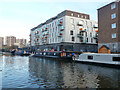
4
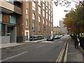
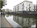
Countryside Properties in the heart of the city
Development at the side of the Regent's Canal, Wiltshire Row.
Image: © Peter Barr
Taken: 3 Nov 2011
0.03 miles
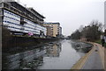
7

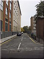
Towerblocks around Haggerston, viewed from the New North Road/Poole Street junction
Looking east-northeast.
Image: © Robert Lamb
Taken: 10 Apr 2011
0.03 miles
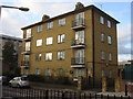
10
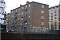
Hoxton Wharf, Wiltshire Row, N1
The block of flats is not actually on the site of a proper wharf, but where a row of houses were along the waterside Wiltshire Row.
Image: © Robin Webster
Taken: 21 Nov 2015
0.03 miles