IMAGES TAKEN NEAR TO
Wargrave Avenue, LONDON, N15 6UA
Introduction
This page details the photographs taken nearby to Wargrave Avenue, N15 6UA by members of the Geograph project.
The Geograph project started in 2005 with the aim of publishing, organising and preserving representative images for every square kilometre of Great Britain, Ireland and the Isle of Man.

There are currently over 7.5m images from over14,400 individuals and you can help contribute to the project by visiting https://www.geograph.org.uk
Image Map
Images are licensed for reuse under creativecommons.org/licenses/by-sa/2.0
Notes
- Clicking on the map will re-center to the selected point.
- The higher the marker number, the further away the image location is from the centre of the postcode.
Image Listing (51 Images Found)
Images are licensed for reuse under creativecommons.org/licenses/by-sa/2.0
Image
Details
Distance
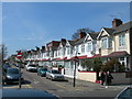
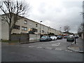
2
Castlewood Road at the junction of Wellington Avenue
Image: © David Howard
Taken: 5 Feb 2014
0.05 miles
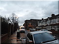
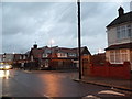
5
Timberwharf Road, Stamford Hill
At the junction of Craven Park Road
Image: © David Howard
Taken: 5 Feb 2014
0.12 miles
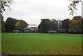
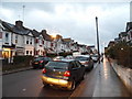
7
Elm Park Avenue looking toward Crowland Primary School
Image: © David Howard
Taken: 5 Feb 2014
0.14 miles
9
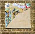
Unfinished mosaic, Crowland Primary School
Image: © Jim Osley
Taken: 18 Jul 2014
0.14 miles
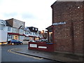
10

Crowland Primary School
Built 1911. http://www.british-history.ac.uk/report.aspx?compid=26998
Image: © Jim Osley
Taken: 18 Jul 2014
0.14 miles