IMAGES TAKEN NEAR TO
Fladbury Road, LONDON, N15 6SH
Introduction
This page details the photographs taken nearby to Fladbury Road, N15 6SH by members of the Geograph project.
The Geograph project started in 2005 with the aim of publishing, organising and preserving representative images for every square kilometre of Great Britain, Ireland and the Isle of Man.

There are currently over 7.5m images from over14,400 individuals and you can help contribute to the project by visiting https://www.geograph.org.uk
Image Map
Images are licensed for reuse under creativecommons.org/licenses/by-sa/2.0
Notes
- Clicking on the map will re-center to the selected point.
- The higher the marker number, the further away the image location is from the centre of the postcode.
Image Listing (134 Images Found)
Images are licensed for reuse under creativecommons.org/licenses/by-sa/2.0
Image
Details
Distance
1
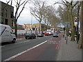
Seven Sisters Road, N15
Near Heysham Road. Traffic is building up on Friday afternoon, heading out of London.
Image: © Danny P Robinson
Taken: 13 Mar 2009
0.02 miles
4
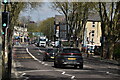
Bus stop and shelter on Seven Sisters Road (A503)
Image: © JThomas
Taken: 20 Jul 2019
0.05 miles
6
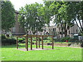
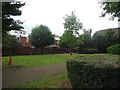
Manchester Road Gardens, Manchester Road, N15
Image: © Mike Quinn
Taken: 7 Jun 2017
0.06 miles
7
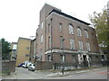
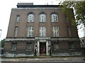
Stamford Hill Telephone Exchange (4)
Taken in Heysham Road, this photo shows the redbrick building with the extension to the left of the photo. It used to have STAmford Hill and LATimer numbers until the late 1960s, and now has 0208-800, 802 and 809 xxxx numbers. A few vehicles can be seen parked in front of the extension building.
Image: © David Hillas
Taken: 26 Oct 2021
0.06 miles
8
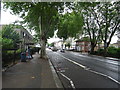
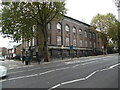
Stamford Hill Telephone Exchange (1)
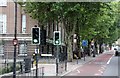
Situated on the A503 Seven Sisters Road, this red brick building would appear to date from the 1930s when several TEs in Greater London were built in that decade. London plane trees can be seen in front of this TE, they being a common sight on London's streets as they can survive air pollution. To the extreme right can be seen Berkeley Road with a 20mph Zone sign and a yellow Covid-19 testing centre board with an arrow pointing right.
Image: © David Hillas
Taken: 26 Oct 2021
0.07 miles
9
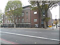
Stamford Hill Telephone Exchange (2)
This photo shows the red brick building in Seven Sisters Road with its entrance in Heysham Road to the left of the photo. The bus stop to the right of the photo is for routes 259, 279 and N279. Also, the blue bus lane sign in the photo mentions that that lane is in use for buses, taxis and cycles on Monday to Saturday between 7.00am and 7.00pm. Two large London plane trees can also be seen in front of the TE.
Image: © David Hillas
Taken: 26 Oct 2021
0.07 miles
10
Stamford Hill Telephone Exchange (3)
Taken in Heysham Road N15 6HL, this photo shows the entrance to the TE which has the code LNSTA. It provides telephone and broadband services to approximately 24,842 residential and 868 non-residential premises in Stamford Hill plus South Tottenham nearby. The wording TELEPHONE EXCHANGE can be seen above the entrance.
Image: © David Hillas
Taken: 26 Oct 2021
0.07 miles