IMAGES TAKEN NEAR TO
Frinton Road, LONDON, N15 6NH
Introduction
This page details the photographs taken nearby to Frinton Road, N15 6NH by members of the Geograph project.
The Geograph project started in 2005 with the aim of publishing, organising and preserving representative images for every square kilometre of Great Britain, Ireland and the Isle of Man.

There are currently over 7.5m images from over14,400 individuals and you can help contribute to the project by visiting https://www.geograph.org.uk
Image Map
Images are licensed for reuse under creativecommons.org/licenses/by-sa/2.0
Notes
- Clicking on the map will re-center to the selected point.
- The higher the marker number, the further away the image location is from the centre of the postcode.
Image Listing (91 Images Found)
Images are licensed for reuse under creativecommons.org/licenses/by-sa/2.0
Image
Details
Distance
1
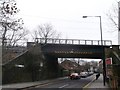
Bridge over St Ann's Road
This road leads from Green Lanes, Harringay towards South Tottenham High Road.
The bridge carries the railway between Seven Sisters and Stamford Hill.
Image: © David Anstiss
Taken: 3 Feb 2013
0.04 miles
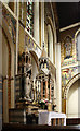
3
St Ignatius Stamford Hill, London N15 - East end
Image: © John Salmon
Taken: 1 Nov 2011
0.10 miles
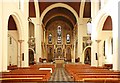
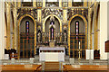
5
St Ignatius, South Tottenham - High altar
Image: © John Salmon
Taken: 19 May 2015
0.10 miles
7
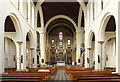
St Ignatius, South Tottenham - East end
Image: © John Salmon
Taken: 19 May 2015
0.11 miles
8
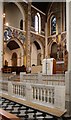
St Ignatius Stamford Hill, London N15 - Chancel
Image: © John Salmon
Taken: 1 Nov 2011
0.11 miles
9
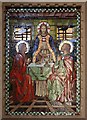
St Ignatius Stamford Hill, London N15 - Mosaic
Image: © John Salmon
Taken: 1 Nov 2011
0.11 miles
10
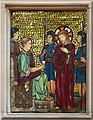
St Ignatius Stamford Hill, London N15 - Station of the Cross No 1
Image: © John Salmon
Taken: 1 Nov 2011
0.11 miles