IMAGES TAKEN NEAR TO
High Road, LONDON, N15 6LY
Introduction
This page details the photographs taken nearby to High Road, N15 6LY by members of the Geograph project.
The Geograph project started in 2005 with the aim of publishing, organising and preserving representative images for every square kilometre of Great Britain, Ireland and the Isle of Man.

There are currently over 7.5m images from over14,400 individuals and you can help contribute to the project by visiting https://www.geograph.org.uk
Image Map
Images are licensed for reuse under creativecommons.org/licenses/by-sa/2.0
Notes
- Clicking on the map will re-center to the selected point.
- The higher the marker number, the further away the image location is from the centre of the postcode.
Image Listing (103 Images Found)
Images are licensed for reuse under creativecommons.org/licenses/by-sa/2.0
Image
Details
Distance
2
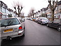
Norfolk Avenue, Stamford Hill
Norfolk Avenue is a residential road in the Stamford Hill area of north London.
Image: © Malc McDonald
Taken: 1 Feb 2020
0.03 miles
3
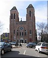
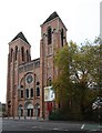
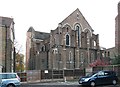
St Ignatius Church on Tottenham High Road from Norfolk Avenue
Image: © David Howard
Taken: 5 Feb 2014
0.03 miles
4
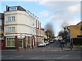
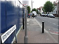
Tottenham High Road
Looking towards Stamford Hill, the road and the postcode.
Image: © David Howard
Taken: 5 Feb 2014
0.03 miles
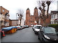
7
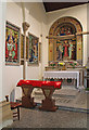
St Ignatius, South Tottenham - North chapel
Image: © John Salmon
Taken: 19 May 2015
0.05 miles
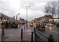
10
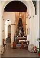
St Ignatius Stamford Hill, London N15 - South chapel
Image: © John Salmon
Taken: 1 Nov 2011
0.05 miles