IMAGES TAKEN NEAR TO
Cadoxton Avenue, LONDON, N15 6LB
Introduction
This page details the photographs taken nearby to Cadoxton Avenue, N15 6LB by members of the Geograph project.
The Geograph project started in 2005 with the aim of publishing, organising and preserving representative images for every square kilometre of Great Britain, Ireland and the Isle of Man.

There are currently over 7.5m images from over14,400 individuals and you can help contribute to the project by visiting https://www.geograph.org.uk
Image Map
Images are licensed for reuse under creativecommons.org/licenses/by-sa/2.0
Notes
- Clicking on the map will re-center to the selected point.
- The higher the marker number, the further away the image location is from the centre of the postcode.
Image Listing (112 Images Found)
Images are licensed for reuse under creativecommons.org/licenses/by-sa/2.0
Image
Details
Distance
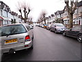
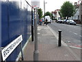
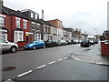
1
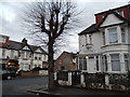
The corner of Rostrevor Avenue and Fairview Road
Image: © David Howard
Taken: 5 Feb 2014
0.05 miles
5
St Bartholomew, Craven Park Road, London N15
Image: © John Salmon
Taken: Unknown
0.09 miles
6
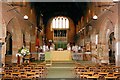
St Bartholomew, Craven Park Road, London N15 - East end
Image: © John Salmon
Taken: Unknown
0.09 miles
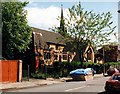
7
St Ignatius Church on Tottenham High Road from Norfolk Avenue
Image: © David Howard
Taken: 5 Feb 2014
0.09 miles
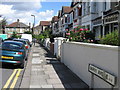
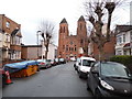
8
Craven Park Road, South Tottenham
At the junction of Fairview Road
Image: © David Howard
Taken: 5 Feb 2014
0.11 miles
9
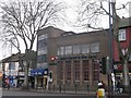
Universal Church of the Kingdom of God, South Tottenham
This modern church is on South Tottenham High Road opposite St Ann's Road.
Image: © David Anstiss
Taken: 3 Feb 2013
0.12 miles
10

Gladesmore Road at the junction of Stamford Hill
Image: © David Howard
Taken: 26 Jan 2022
0.12 miles