IMAGES TAKEN NEAR TO
Ermine Road, LONDON, N15 6DB
Introduction
This page details the photographs taken nearby to Ermine Road, N15 6DB by members of the Geograph project.
The Geograph project started in 2005 with the aim of publishing, organising and preserving representative images for every square kilometre of Great Britain, Ireland and the Isle of Man.

There are currently over 7.5m images from over14,400 individuals and you can help contribute to the project by visiting https://www.geograph.org.uk
Image Map
Images are licensed for reuse under creativecommons.org/licenses/by-sa/2.0
Notes
- Clicking on the map will re-center to the selected point.
- The higher the marker number, the further away the image location is from the centre of the postcode.
Image Listing (115 Images Found)
Images are licensed for reuse under creativecommons.org/licenses/by-sa/2.0
Image
Details
Distance
1
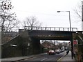
Bridge over St Ann's Road
This road leads from Green Lanes, Harringay towards South Tottenham High Road.
The bridge carries the railway between Seven Sisters and Stamford Hill.
Image: © David Anstiss
Taken: 3 Feb 2013
0.08 miles
2
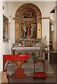
St Ignatius Stamford Hill, London N15 - North chapel
Image: © John Salmon
Taken: 1 Nov 2011
0.08 miles
3

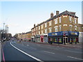
Stamford Hill at the junction of Gladesmore Road
Image: © David Howard
Taken: 26 Jan 2022
0.08 miles
4
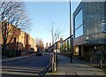
High Road, South Tottenham
High Road passing through South Tottenham in the suburbs of north London. This road forms part of the route of the trunk A10 road.
Image: © Malc McDonald
Taken: 1 Feb 2020
0.08 miles
5

High Road Tottenham at the junction of Ferndale Road
Image: © David Howard
Taken: 26 Jan 2022
0.08 miles
6

Fernlea Surgery on High Road, Tottenham
Image: © David Howard
Taken: 26 Jan 2022
0.08 miles

8

Gladesmore Road at the junction of Stamford Hill
Image: © David Howard
Taken: 26 Jan 2022
0.08 miles
9
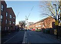
Plevna Crescent, South Tottenham
The cranes in the distance are on the site of the former St Ann's Hospital.
Image: © Bikeboy
Taken: 2 Jan 2025
0.09 miles