IMAGES TAKEN NEAR TO
Cissbury Road, LONDON, N15 5PU
Introduction
This page details the photographs taken nearby to Cissbury Road, N15 5PU by members of the Geograph project.
The Geograph project started in 2005 with the aim of publishing, organising and preserving representative images for every square kilometre of Great Britain, Ireland and the Isle of Man.

There are currently over 7.5m images from over14,400 individuals and you can help contribute to the project by visiting https://www.geograph.org.uk
Image Map
Images are licensed for reuse under creativecommons.org/licenses/by-sa/2.0
Notes
- Clicking on the map will re-center to the selected point.
- The higher the marker number, the further away the image location is from the centre of the postcode.
Image Listing (129 Images Found)
Images are licensed for reuse under creativecommons.org/licenses/by-sa/2.0
Image
Details
Distance
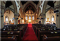
2
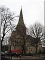
St Ann?s Church, St Ann?s Road, South Tottenham
A winter view through the bare trees.
Image: © Richard Rogerson
Taken: 28 Jan 2010
0.04 miles

5
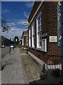
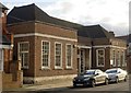
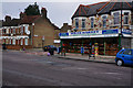
St Ann's Library South Tottenham
The library is housed in a rather well proportioned and well designed public building dating I would guess from the 1920's or 1930's in a style called neo-Georgian. This is the view north up Cissbury Road.
Image: © John Kingdon
Taken: 1 Aug 2023
0.06 miles
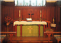
6

St Ann, South Tottenham - Stained glass window
Image: © John Salmon
Taken: 27 Feb 2013
0.07 miles
10
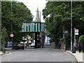
St Ann's Church Spire And Railway Bridge South Tottenham
The railway bridge in the foreground carries the Gospel Oak to Barking line over the Seven Sisters Road and St Ann's Road. The spire of St Ann's Church rises behind it.
Image: © John Kingdon
Taken: 1 Aug 2023
0.08 miles