IMAGES TAKEN NEAR TO
Stonebridge Road, LONDON, N15 5PB
Introduction
This page details the photographs taken nearby to Stonebridge Road, N15 5PB by members of the Geograph project.
The Geograph project started in 2005 with the aim of publishing, organising and preserving representative images for every square kilometre of Great Britain, Ireland and the Isle of Man.

There are currently over 7.5m images from over14,400 individuals and you can help contribute to the project by visiting https://www.geograph.org.uk
Image Map
Images are licensed for reuse under creativecommons.org/licenses/by-sa/2.0
Notes
- Clicking on the map will re-center to the selected point.
- The higher the marker number, the further away the image location is from the centre of the postcode.
Image Listing (199 Images Found)
Images are licensed for reuse under creativecommons.org/licenses/by-sa/2.0
Image
Details
Distance
4
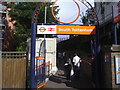
High Road, N15
Outside South Tottenham Station.
Image: © Danny P Robinson
Taken: 3 Dec 2006
0.05 miles
5
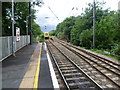
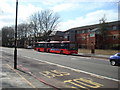
A London Overground train heads away from South Tottenham station
The Tottenham & Hampstead Junction Railway was planned to run from Tottenham Hale on the Great Eastern Railway to Gospel Oak on the Hampstead Junction section of the London & North Western Railway. It was worked by the North London Railway (NLR) from its opening in 1860, and in 1864 came under NLR control. On 21st July 1868 a new line opened from Tottenham Hale to Highgate Road. It was only in 1887 that an extension to Gospel Oak was achieved but as a passenger exchange not as a junction.
On 9th July 1894, the Tottenham & Forest Gate Railway was opened for through goods and passenger trains and had stations at Blackhorse Road, Walthamstow, Leyton, Leytonstone and Wanstead Park. Up to 1912 the line was a joint railway operated by the Midland Railway and the London, Tilbury & Southend Railway but from 1912 it was solely operated by the Midland. With the opening of the new line the Midland extended some of its South Tottenham trains to East Ham.
The line which now ran between Kentish Town and Barking was considered for closure to passengers in 1963 as part of the Beeching Axe, but it remained open. Even so, it was allowed to fall into a poor state of repair and reliability, and by 1980 had been cut back to an hourly service between Kentish Town and Barking. The station canopies were gradually demolished, ticket offices closed and staff withdrawn from stations.
The situation began to improve from 1981 when a new link to Gospel Oak was built and the hourly service from Kentish Town to Barking was replaced by the present route from Gospel Oak to Barking with two trains per hour.
Now with it being taken over by Transport for London as part of the London Overground network the whole line has a new lease of life and new trains run every 15 minutes between Barking and Gospel Oak.
South Tottenham station was opened on 1st May 1871 as 'Tottenham and Stamford Hill' station and became 'South Tottenham' on 1st July 1903. The bridge over Tottenham High Road is just ahead and beyond, the curve to the right leads to Seven Sisters station on Greater Anglia although this is not used by normal passenger trains. The next station straight ahead is Harringay Green Lanes, although St Ann's Road station was closer but this closed in 1942. An Overground train bound for Gospel Oak can be seen heading away from the station.
Image: © Marathon
Taken: 4 Jun 2014
0.06 miles
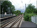
8
View from the end of the platform at South Tottenham station
The Tottenham & Hampstead Junction Railway was planned to run from Tottenham Hale on the Great Eastern Railway to Gospel Oak on the Hampstead Junction section of the London & North Western Railway. It was worked by the North London Railway (NLR) from its opening in 1860, and in 1864 came under NLR control. On 21st July 1868 a new line opened from Tottenham Hale to Highgate Road. It was only in 1887 that an extension to Gospel Oak was achieved but as a passenger exchange not as a junction.
On 9th July 1894, the Tottenham & Forest Gate Railway was opened for through goods and passenger trains and had stations at Blackhorse Road, Walthamstow, Leyton, Leytonstone and Wanstead Park. Up to 1912 the line was a joint railway operated by the Midland Railway and the London, Tilbury & Southend Railway but from 1912 it was solely operated by the Midland. With the opening of the new line the Midland extended some of its South Tottenham trains to East Ham.
The line which now ran between Kentish Town and Barking was considered for closure to passengers in 1963 as part of the Beeching Axe, but it remained open. Even so, it was allowed to fall into a poor state of repair and reliability, and by 1980 had been cut back to an hourly service between Kentish Town and Barking. The station canopies were gradually demolished, ticket offices closed and staff withdrawn from stations.
The situation began to improve from 1981 when a new link to Gospel Oak was built and the hourly service from Kentish Town to Barking was replaced by the present route from Gospel Oak to Barking with two trains per hour.
Now with it being taken over by Transport for London as part of the London Overground network the whole line has a new lease of life and new trains run every 15 minutes between Barking and Gospel Oak.
South Tottenham station was opened on 1st May 1871 as 'Tottenham and Stamford Hill' station and became 'South Tottenham' on 1st July 1903. The bridge over Tottenham High Road is just ahead and beyond, the curve to the right leads to Seven Sisters station on Greater Anglia although this is not used by normal passenger trains. The next station straight ahead is Harringay Green Lanes, although St Ann's Road station was closer but this closed in 1942. An Overground train bound for Gospel Oak can be seen heading away from the station.
Image: © Marathon
Taken: 4 Jun 2014
0.07 miles
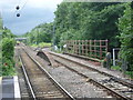
9
View west from South Tottenham station
The Tottenham & Hampstead Junction Railway was planned to run from Tottenham Hale on the Great Eastern Railway to Gospel Oak on the Hampstead Junction section of the London & North Western Railway. It was worked by the North London Railway (NLR) from its opening in 1860, and in 1864 came under NLR control. On 21st July 1868 a new line opened from Tottenham Hale to Highgate Road. It was only in 1887 that an extension to Gospel Oak was achieved but as a passenger exchange not as a junction.
On 9th July 1894, the Tottenham & Forest Gate Railway was opened for through goods and passenger trains and had stations at Blackhorse Road, Walthamstow, Leyton, Leytonstone and Wanstead Park. Up to 1912 the line was a joint railway operated by the Midland Railway and the London, Tilbury & Southend Railway but from 1912 it was solely operated by the Midland. With the opening of the new line the Midland extended some of its South Tottenham trains to East Ham.
The line which now ran between Kentish Town and Barking was considered for closure to passengers in 1963 as part of the Beeching Axe, but it remained open. Even so, it was allowed to fall into a poor state of repair and reliability, and by 1980 had been cut back to an hourly service between Kentish Town and Barking. The station canopies were gradually demolished, ticket offices closed and staff withdrawn from stations.
The situation began to improve from 1981 when a new link to Gospel Oak was built and the hourly service from Kentish Town to Barking was replaced by the present route from Gospel Oak to Barking with two trains per hour.
Now with it being taken over by Transport for London as part of the London Overground network the whole line has a new lease of life and new trains run every 15 minutes between Barking and Gospel Oak.
South Tottenham station was opened on 1st May 1871 as 'Tottenham and Stamford Hill' station and became 'South Tottenham' on 1st July 1903. The bridge over Tottenham High Road is just ahead and beyond, a curve to the right leads to Seven Sisters station on Greater Anglia although this is not used by normal passenger trains. It is better seen in this photograph from the opposite platform http://www.geograph.org.uk/photo/4016820 The next station straight ahead is Harringay Green Lanes, although St Ann's Road station was closer but this closed in 1942.
Image: © Marathon
Taken: 4 Jun 2014
0.07 miles
10

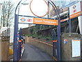
South Tottenham Station : roundel in mosaic
For a description of the project to create mosaic roundels for stations of the London Overground see this https://artyface.co.uk/wp/projects/station-roundels/.
Image: © Jim Osley
Taken: 6 Nov 2020
0.07 miles