IMAGES TAKEN NEAR TO
Victoria Crescent, LONDON, N15 5LU
Introduction
This page details the photographs taken nearby to Victoria Crescent, N15 5LU by members of the Geograph project.
The Geograph project started in 2005 with the aim of publishing, organising and preserving representative images for every square kilometre of Great Britain, Ireland and the Isle of Man.

There are currently over 7.5m images from over14,400 individuals and you can help contribute to the project by visiting https://www.geograph.org.uk
Image Map
Images are licensed for reuse under creativecommons.org/licenses/by-sa/2.0
Notes
- Clicking on the map will re-center to the selected point.
- The higher the marker number, the further away the image location is from the centre of the postcode.
Image Listing (134 Images Found)
Images are licensed for reuse under creativecommons.org/licenses/by-sa/2.0
Image
Details
Distance
1
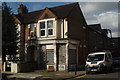
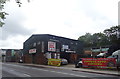
Martins the Butchers Culvert Road N15
Beneath the peeling paint one can still read the shop sign. When these streets were first laid out at the start of the twentieth century each corner had a shop. This was the butcher's not the baker's or indeed the candlestick maker's.
Image: © John Kingdon
Taken: 21 Mar 2017
0.05 miles
4
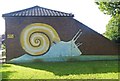
Snail mural, Seven Sisters Road
According to this http://edithsstreets.blogspot.co.uk/2012/06/stonebridge-brook-south-tottenham.html , the "St Ann's Snail" mural dates from 1976 as part of the Silver Jubilee celebrations and it is called Sid.
Image: © Jim Osley
Taken: 18 Jul 2014
0.05 miles
6
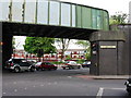
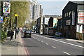
Seven Sisters
The railway bridge at the junction of Seven Sisters Road and St Ann's Road, South Tottenham. The bridge is unusual as it crosses the road junction diagonally. The railway (now part of London Overground) runs from Gospel Oak to Barking. The station here, called "St Ann's Road", was a wartime casualty, closing on 9 August 1942. The nearest station is now South Tottenham, less than a mile away on Tottenham High Road.
Image: © Vicky Ayech
Taken: 7 May 2005
0.06 miles
10
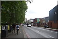
Seven Sisters Road N15
Looking towards Culvert Road. Seven Sisters Station is about half a mile from here in this direction.
Image: © Danny P Robinson
Taken: 18 Jun 2006
0.09 miles