IMAGES TAKEN NEAR TO
Ida Road, LONDON, N15 5JL
Introduction
This page details the photographs taken nearby to Ida Road, N15 5JL by members of the Geograph project.
The Geograph project started in 2005 with the aim of publishing, organising and preserving representative images for every square kilometre of Great Britain, Ireland and the Isle of Man.

There are currently over 7.5m images from over14,400 individuals and you can help contribute to the project by visiting https://www.geograph.org.uk
Image Map
Images are licensed for reuse under creativecommons.org/licenses/by-sa/2.0
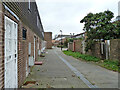
Notes
- Clicking on the map will re-center to the selected point.
- The higher the marker number, the further away the image location is from the centre of the postcode.
Image Listing (134 Images Found)
Images are licensed for reuse under creativecommons.org/licenses/by-sa/2.0
Image
Details
Distance
1
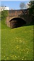
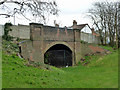
Avenue Road bridge over abandoned railway
Just to the east of the former West Green station the land seems to have returned to idyllic pasture. The track bed on the other side of the fenced off structure was long ago turned over to allotments. As in my photo (5341737) of the next bridge over the railway to the west there is a white painted building on the north east corner.
Image: © John Kingdon
Taken: 8 Apr 2017
0.03 miles
2
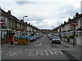
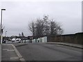
Elmar Road, N15
The houses are typical of the area.
Image: © Danny P Robinson
Taken: 24 Mar 2008
0.03 miles
3
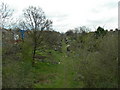
Allotments on a Disused Railway
Taken from Avenue Road, N15.
Image: © Danny P Robinson
Taken: 24 Mar 2008
0.03 miles
4
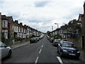
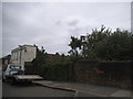
Seaford Road, N15
Viewed from Avenue Road.
Image: © Danny P Robinson
Taken: 24 Mar 2008
0.03 miles
5
Bridge over abandoned Palace Gates branch
The Palace Gates branch was opened in 1878 by the Great Eastern Railway, and closed to passengers in 1963 and goods in 1964. The bridge carries Avenue Road, whose width is reduced over the bridge, so there must be doubt about its strength now. This side of the bridge is a housing estate, the other, some allotments, but generally all the branch is built over now.
Image: © Robin Webster
Taken: 5 Feb 2011
0.03 miles
6
Avenue Road Bridge, South Tottenham
This road leads from Green Road to St Anns Road.
It passes over a former railway line (the Palace Gates Line),between Seven Sisters station in Tottenham to Palace Gates (Wood Green) station in Wood Green.
Image: © David Anstiss
Taken: 3 Feb 2013
0.04 miles
7
Imaginary bridge, Avenue Road
This used to go over a railway which carried its last passengers to exotic stations such as nearby West Green until the 1950s, but no longer physically exists. It has an equivalent overbridge across West Green Road by what was the old station just to the east as well, which is doing very little.
Image: © David Howard
Taken: 30 May 2014
0.04 miles
8
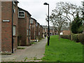
Sturrock Close, N15
Road access is from the other side of this row.
Image: © Robin Webster
Taken: 5 Feb 2011
0.05 miles
10
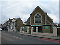
West Green Baptist Church, Tottenham
On West Green Road, near Dorset Road. This building was commissioned by the Rev. George Newenham Watson (1806-1869). Building began in 1864 and from his private means he provided the money to meet the bills as they became due. The total cost was about £2400. Some time in 1865 the Chapel was opened for public worship. Mr Watson carried on his ministry for three-and-a-half years in the new building, and then ill-health compelled him reluctantly to give up. He died on 7th Dec 1869.
Image: © Danny P Robinson
Taken: 24 Mar 2008
0.05 miles