IMAGES TAKEN NEAR TO
Watts Close, LONDON, N15 5DW
Introduction
This page details the photographs taken nearby to Watts Close, N15 5DW by members of the Geograph project.
The Geograph project started in 2005 with the aim of publishing, organising and preserving representative images for every square kilometre of Great Britain, Ireland and the Isle of Man.

There are currently over 7.5m images from over14,400 individuals and you can help contribute to the project by visiting https://www.geograph.org.uk
Image Map
Images are licensed for reuse under creativecommons.org/licenses/by-sa/2.0
Notes
- Clicking on the map will re-center to the selected point.
- The higher the marker number, the further away the image location is from the centre of the postcode.
Image Listing (147 Images Found)
Images are licensed for reuse under creativecommons.org/licenses/by-sa/2.0
Image
Details
Distance
1
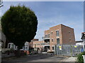
New Council Housing Development Greenfield Road N15
The simple right angled geometric blocks (nicely contrasting with the circular shaped tree) owe much to the Bauhaus School of Design. The building also reflects a public and private corporate style much used in the 1930's-1950's of a longer lower recessed frontage between larger taller end blocks. Reminiscent of Hornsey Town Hall only a couple of miles away. Doubtless the flat roof will cause later problems but for now a pleasing piece of public building. Not only not out of keeping with its surroundings but a relief from the tyranny of bland high rise developments in the Borough.
Image: © John Kingdon
Taken: 7 Oct 2023
0.01 miles
2
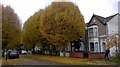
Leaf Fall at Greenfield Road N15
More a photo of someone else taking a photo of these beautifully pollarded trees.
Image: © John Kingdon
Taken: 26 Nov 2019
0.05 miles
3
Roslyn Road to Southey Road Closed Alleyway
This alleyway was closed and abandoned some years ago on the grounds that it had encouraged criminality and anti-social behaviour. Since closure it has filled up with litter and a buddleia tree has taken over this entrance on Roslyn Road. Just behind the tree inside the alleyway there remains a modern lamppost that no longer works.
Image: © John Kingdon
Taken: 13 Jul 2023
0.05 miles
4
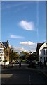
Roslyn Road cloudscene
Looking down Roslyn Road to the railway arches on which sits Seven Sisters station. Overhead the odd shaped cloud is, I believe, called cirrus vertebratus. It looks like a fluffy insect about to land.
Image: © John Kingdon
Taken: 25 Oct 2017
0.06 miles
5
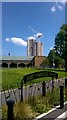
Brunswick Park N15
This is the site of the old Seven Sisters station on the branch line to Palace Gates. It stood on curving brick arches like those of the surviving station in the background. The ghastly/ghostly tower block arises in the background. See also Image
Image: © John Kingdon
Taken: 16 May 2019
0.07 miles
7
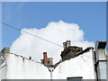
Brunswick Road N15 rooftops
The prosaic backside of the buildings that front West Green Road contrast nicely with the beauty of the sky scene. It reminds me of the line about the city's ripped backside from Iggy Pop's song 'The Passenger'.
Image: © John Kingdon
Taken: 1 Oct 2019
0.09 miles
8
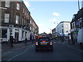
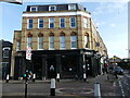
Shops on West Green Road, South Tottenham
Image: © David Howard
Taken: 8 Dec 2016
0.10 miles
9
True Craft pub West Green Road London N15
Up until only 7 years ago this pub was called simply the West Green although often it was referred to as the West Green Tavern. It was a pub that served almost exclusively the local African-Caribbean population. Now it has been made over and serves a hipster clientele as gentrification moves on apace in an area that once had affordable housing but now does not. In this process I always wonder where the displaced populations go.
Image: © John Kingdon
Taken: 9 Feb 2023
0.10 miles
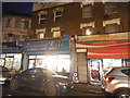
10
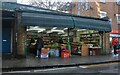
Greengrocers on West Green Road, South Tottenham
Image: © David Howard
Taken: 31 Oct 2020
0.10 miles