IMAGES TAKEN NEAR TO
Gresley Close, LONDON, N15 5BQ
Introduction
This page details the photographs taken nearby to Gresley Close, N15 5BQ by members of the Geograph project.
The Geograph project started in 2005 with the aim of publishing, organising and preserving representative images for every square kilometre of Great Britain, Ireland and the Isle of Man.

There are currently over 7.5m images from over14,400 individuals and you can help contribute to the project by visiting https://www.geograph.org.uk
Image Map (Loading...)


Getting Data...Please wait
Leaflet Map data © OpenStreetMap
Images are licensed for reuse under creativecommons.org/licenses/by-sa/2.0
Notes
- Clicking on the map will re-center to the selected point.
- The higher the marker number, the further away the image location is from the centre of the postcode.
Image Listing (99 Images Found)
Images are licensed for reuse under creativecommons.org/licenses/by-sa/2.0
Image
Details
Distance
3
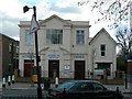
Tottenham Seventh-Day Adventist Church
On the corner of West Green Road and Cornwall Road. In England you will tend to find a higher concentration of Seventh-Day Adventist Churches in areas where immigrants from the Caribbean originally settled, as the denomination is a significant one in the Caribbean. It actually has its origins in the USA and a presence worldwide but in the UK for historical reasons it is most strongly identified with particular ethnic groups.
Image: © Danny P Robinson
Taken: 21 Mar 2008
0.01 miles

5
Cornwall Road bridge over abandoned railway
The roadside fencing panels have disappeared allowing access to take this view of the bricked up bridge. Trains from Palace Gates to Stratford via Seven Sisters ran under this road bridge until the mid 1960's.
Image: © John Kingdon
Taken: 8 Apr 2017
0.03 miles
6
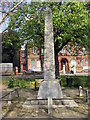
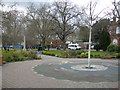
WW1 War Memorial
West Green, outside Downhills Park
Image: © Christine Westerback
Taken: 13 Apr 2012
0.04 miles
7
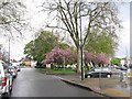
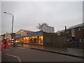
West Green Road
The roundabout at its junction with Blackboys Road and Philip Lane
Image: © Vicky Ayech
Taken: 19 Apr 2005
0.04 miles
8
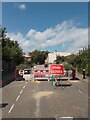
Cornwall Road N15 permanent closure over bridge
Where Cornwall Road sits on a bridge over the abandoned railway line that ran from Seven Sisters station to Palace Gates station until closure in 1964 that too has now been closed to traffic. Wooden planter boxes and cast iron bollards have been fixed in the road at either end of the bridge to stop all vehicular traffic. I assume that the bridge has now been found to be too structurally weak to take anything other than pedestrians and cyclists. My photo Image] from a few years ago gives a glimpse of the bridge's steel span from the west side.
Image: © John Kingdon
Taken: 22 Jul 2024
0.04 miles
9
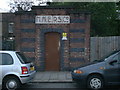
Electricity Substation
An electricity substation in Cornwall Road, N15. The initials indicate that it was originally built by the North Metropolitan Electric Power Supply Company (Northmet), based in Wood Green.
Image: © Arb
Taken: 5 Apr 2011
0.04 miles
10
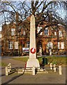
West Green obeliskoid war memorial, South Tottenham
For more visit this http://tottenham-summerhillroad.com/west_green_memorial.htm.
Image: © Jim Osley
Taken: 20 Dec 2013
0.04 miles