IMAGES TAKEN NEAR TO
Cornwall Road, LONDON, N15 5AX
Introduction
This page details the photographs taken nearby to Cornwall Road, N15 5AX by members of the Geograph project.
The Geograph project started in 2005 with the aim of publishing, organising and preserving representative images for every square kilometre of Great Britain, Ireland and the Isle of Man.

There are currently over 7.5m images from over14,400 individuals and you can help contribute to the project by visiting https://www.geograph.org.uk
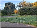
Image Map
Images are licensed for reuse under creativecommons.org/licenses/by-sa/2.0
Notes
- Clicking on the map will re-center to the selected point.
- The higher the marker number, the further away the image location is from the centre of the postcode.
Image Listing (128 Images Found)
Images are licensed for reuse under creativecommons.org/licenses/by-sa/2.0
Image
Details
Distance
3
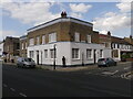
The Prince of Wales pub (as was) Alexandra Road N15
This building, now used as flats, was the Prince of Wales pub until about fifteen years ago. It was my neighbour's local until he died seventeen years ago. It had a largely Irish clientele and my neighbour swore by the Guinness they poured there. I spoke with the guy in the photo who also remembered when it was a pub and was happy to be included in the shot.
Image: © John Kingdon
Taken: 29 Jun 2023
0.04 miles
4
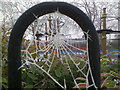
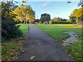
Chestnuts Park spider web
A cold morning in the children's play area
Image: © John Kingdon
Taken: 12 Dec 2012
0.05 miles
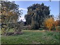
5
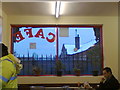
Chestnut's Cafe
St Ann's Hospital seen through the cafe window on a snowy day in 2013. The hospital soon to be "redeveloped" into housing on the majority of the site. I used to take my elderly neighbour there for an injection into her eyeball. This was her last year on this earth.
Image: © John Kingdon
Taken: 23 Jan 2013
0.05 miles
6
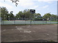
Basketball and Tennis Courts
Basketball and Tennis Courts in Chestnuts Recreation Ground
Image: © Shaun Ferguson
Taken: 11 May 2009
0.05 miles
9
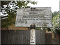
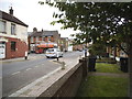
Old council sign on Cornwall Road
Tottenham council merged to form Haringey in 1965 when Greater London was created. It was not part of the pre-Worboys system as councils issued off-road signs such as this rather than the Department of Transport, and were not standardised like the others.
Image: © David Howard
Taken: 30 May 2014
0.08 miles
10
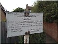
Tottenham Borough Council Sign Cornwall Road N15
Tottenham Borough Council disappeared in 1965 to be subsumed into the London Borough of Haringey. Here its neglected sign still stands warning that the riding of bicycles, tricycles or other similar machines on the footpath is prohibited and subject to a £2 penalty fine. Today this warning is ignored as the users of such machines plus e-scooters happily ride on the pavements without fear of sanction. The fine in 1965 would be about a tenth of an average national weekly wage so today about £60.
Image: © John Kingdon
Taken: 19 Sep 2022
0.08 miles