IMAGES TAKEN NEAR TO
Stonemasons Close, LONDON, N15 5AL
Introduction
This page details the photographs taken nearby to Stonemasons Close, N15 5AL by members of the Geograph project.
The Geograph project started in 2005 with the aim of publishing, organising and preserving representative images for every square kilometre of Great Britain, Ireland and the Isle of Man.

There are currently over 7.5m images from over14,400 individuals and you can help contribute to the project by visiting https://www.geograph.org.uk
Image Map
Images are licensed for reuse under creativecommons.org/licenses/by-sa/2.0
Notes
- Clicking on the map will re-center to the selected point.
- The higher the marker number, the further away the image location is from the centre of the postcode.
Image Listing (103 Images Found)
Images are licensed for reuse under creativecommons.org/licenses/by-sa/2.0
Image
Details
Distance

2
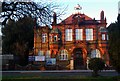
Former Tottenham School Board offices (1899)
Currently occupied by an independent school, the Wisdom Primary and Secondary School.
Image: © Jim Osley
Taken: 21 Jan 2011
0.06 miles
3
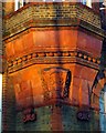
Tottenham School Board monogram
On the former Tottenham School Board office building, Philip Lane, London N15.
Image: © Jim Osley
Taken: 21 Jan 2011
0.06 miles
4
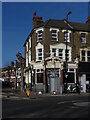
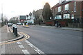
Ex Pub of Unknown Name on Philip Lane London N15
I have searched in vain to find out what this once pub was called. There is a website on the pubs of Tottenham but this one does not feature so I imagine it closed quite some time ago.
Image: © John Kingdon
Taken: 9 Feb 2023
0.06 miles
5
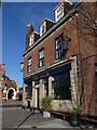
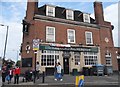
The Palm pub 197 Philip Lane N15
This was the Lord Palmerston pub until about 5 years ago. That was a working class and down at heel pub now revamped and gentrified to serve more hipster patrons. A sign of the encroaching gentrification in N15. At least the building was not demolished for some hideous block of flats and retains the lovely glazed tiling along the bottom of the walls. Also one can see below the near window the tile embossed THB. This stood for Truman Hanbury Buxton, the brewery in East London that built this elegant pub, I think, in the inter war years.
Image: © John Kingdon
Taken: 9 Feb 2023
0.08 miles
8
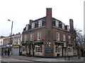
The Lord Palmerston pub, Haringey
On the junction of Philip Lane and Summerhill Road (on the right).
Image: © David Anstiss
Taken: 3 Feb 2013
0.10 miles
9
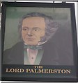
The Lord Palmerston pub sign, Haringey
On Image
Image: © David Anstiss
Taken: 3 Feb 2013
0.10 miles
10
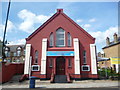
New Testament Assembly, Philip Lane N15
Image: © Robin Sones
Taken: 29 Aug 2013
0.10 miles