IMAGES TAKEN NEAR TO
Beaconsfield Road, LONDON, N15 4SH
Introduction
This page details the photographs taken nearby to Beaconsfield Road, N15 4SH by members of the Geograph project.
The Geograph project started in 2005 with the aim of publishing, organising and preserving representative images for every square kilometre of Great Britain, Ireland and the Isle of Man.

There are currently over 7.5m images from over14,400 individuals and you can help contribute to the project by visiting https://www.geograph.org.uk
Image Map
Images are licensed for reuse under creativecommons.org/licenses/by-sa/2.0
Notes
- Clicking on the map will re-center to the selected point.
- The higher the marker number, the further away the image location is from the centre of the postcode.
Image Listing (170 Images Found)
Images are licensed for reuse under creativecommons.org/licenses/by-sa/2.0
Image
Details
Distance
2
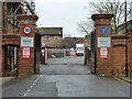
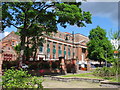
Gates to Portland Place
A gated estate on the site of cold stores, earlier the site was a brewery and ice factory.
Image: © Robin Webster
Taken: 22 Jan 2011
0.08 miles
3
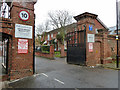
Gates to Portland Place
A gated estate on the site of cold stores, earlier the site was a brewery and ice factory.
Image: © Robin Webster
Taken: 22 Jan 2011
0.08 miles
4
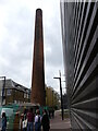
Industrial Chimney at the Bernie Grant Arts Centre Tottenham
My 1964 A-Z tells me that there was once a hospital and a technical school on a road called Eagle Avenue where now stands the Bernie Grant Arts Centre. Might the chimney that survives have been for burning hospital waste? It is April 2021 and some can still be seen wearing face masks to prevent the spread of Covid 19.
Image: © John Kingdon
Taken: 21 Apr 2021
0.10 miles
5
The College of North East London
Known as CONEL
Image: © Vicky Ayech
Taken: 7 May 2005
0.11 miles
6
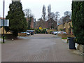
Housing estate off Pelham Road
A fairly modern estate that appears to be on the site of late Victorian high density housing.
Image: © Robin Webster
Taken: 22 Jan 2011
0.12 miles
7
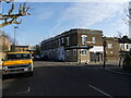
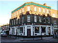
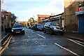
Clyde Road London N15 Row of closed shops and pub
Our local council urge us to walk and cycle to shop local but as this photo shows, the days of the back street parade of shops is long past. All are now housing. The people who live here doubtless commute from the nearby Seven Sisters station and shop elsewhere. Clyde Road and Beaconsfield Road shown here are almost deserted throughout the day.
Of interest is the yellow American Ford left hand drive van. Its number plate suggests it is at least 52 years old. Its width exceeds the UK parking bay size.
Image: © John Kingdon
Taken: 9 Feb 2023
0.12 miles
8
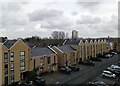
NEW
New housing off Lawrence Street, N15
Built on the site of former small industrial units
Image: © Bikeboy
Taken: 22 Feb 2025
0.13 miles
10
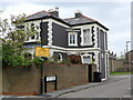
Clyde Road London N15 once prestigious house
This beautiful old property boasts marvellous octagonal windows, and architraves around the others. It is one of a pair of buildings in the area which have lost their gardens to housing and have been turned into flats which gives them a rather hemmed in appearance. The slate roof on this one looks like it is going to need some attendance.
Image: © John Kingdon
Taken: 21 Apr 2021
0.13 miles