IMAGES TAKEN NEAR TO
Broad Lane, LONDON, N15 4QX
Introduction
This page details the photographs taken nearby to Broad Lane, N15 4QX by members of the Geograph project.
The Geograph project started in 2005 with the aim of publishing, organising and preserving representative images for every square kilometre of Great Britain, Ireland and the Isle of Man.

There are currently over 7.5m images from over14,400 individuals and you can help contribute to the project by visiting https://www.geograph.org.uk
Image Map
Images are licensed for reuse under creativecommons.org/licenses/by-sa/2.0
Notes
- Clicking on the map will re-center to the selected point.
- The higher the marker number, the further away the image location is from the centre of the postcode.
Image Listing (124 Images Found)
Images are licensed for reuse under creativecommons.org/licenses/by-sa/2.0
Image
Details
Distance
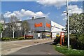
2
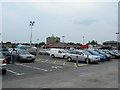
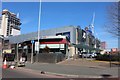
Tottenham Hale Retail Park
Outside Lidl, looking towards Staples and Burger King.
Image: © Danny P Robinson
Taken: 18 Jun 2006
0.06 miles
3
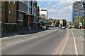
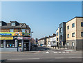
Tottenham Hale Retail Park from Broad Lane
Image: © David Howard
Taken: 23 Mar 2020
0.07 miles
5
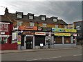
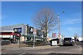
Businesses on Broad Lane, Tottenham Hale
Image: © Neil Theasby
Taken: 21 Apr 2018
0.08 miles
6
Tottenham Hale Retail Park from Broad Lane
Image: © David Howard
Taken: 23 Mar 2020
0.09 miles
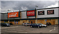
7
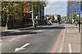
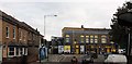
Antill Road, Tottenham Hale, London N17
As seen from Costa Coffee.
Image: © Christine Matthews
Taken: 9 Apr 2015
0.09 miles
8
Broad Lane into Fountayne Road, London N15
Image: © John Salmon
Taken: 18 Jul 2009
0.09 miles
10
Tottenham Hale Retail Park
... after the looting in August 2011. Full background at this http://www.telegraph.co.uk/news/uknews/crime/8687518/Tottenham-riots-how-a-peaceful-vigil-led-to-devastating-carnage.html
Image: © Jim Osley
Taken: 12 Aug 2011
0.10 miles