IMAGES TAKEN NEAR TO
High Road, LONDON, N15 4NP
Introduction
This page details the photographs taken nearby to High Road, N15 4NP by members of the Geograph project.
The Geograph project started in 2005 with the aim of publishing, organising and preserving representative images for every square kilometre of Great Britain, Ireland and the Isle of Man.

There are currently over 7.5m images from over14,400 individuals and you can help contribute to the project by visiting https://www.geograph.org.uk
Image Map
Images are licensed for reuse under creativecommons.org/licenses/by-sa/2.0
Notes
- Clicking on the map will re-center to the selected point.
- The higher the marker number, the further away the image location is from the centre of the postcode.
Image Listing (214 Images Found)
Images are licensed for reuse under creativecommons.org/licenses/by-sa/2.0
Image
Details
Distance

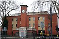
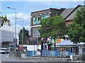
3
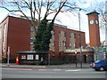
Apex House, Seven Sisters
Haringey Council office
Image: © Stacey Harris
Taken: 22 Mar 2010
0.02 miles
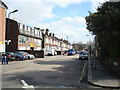
7
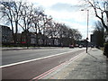
Junction of Pembroke Road N15 and Page Green Terrace N15
Image: © Robin Sones
Taken: 15 Feb 2009
0.03 miles
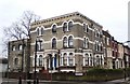
9
Haringey Council building, High Road N15
Image: © Robin Sones
Taken: 15 Feb 2009
0.04 miles
10
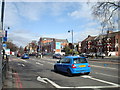
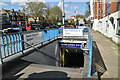
High Road / Seven Sisters Road, South Tottenham
Shows one of the entrances to Seven Sisters tube station (Victoria Line). There are no station entrance buildings on the High Road - but see Image
Image: © Mike Quinn
Taken: 7 Jun 2017
0.04 miles