IMAGES TAKEN NEAR TO
Wakefield Road, LONDON, N15 4NH
Introduction
This page details the photographs taken nearby to Wakefield Road, N15 4NH by members of the Geograph project.
The Geograph project started in 2005 with the aim of publishing, organising and preserving representative images for every square kilometre of Great Britain, Ireland and the Isle of Man.

There are currently over 7.5m images from over14,400 individuals and you can help contribute to the project by visiting https://www.geograph.org.uk
Image Map
Images are licensed for reuse under creativecommons.org/licenses/by-sa/2.0
Notes
- Clicking on the map will re-center to the selected point.
- The higher the marker number, the further away the image location is from the centre of the postcode.
Image Listing (215 Images Found)
Images are licensed for reuse under creativecommons.org/licenses/by-sa/2.0
Image
Details
Distance

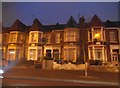
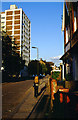
3
Broad Lane, N15 (2)
The north side, west of Talbot Road. Shows the location of Image
Image: © Mike Quinn
Taken: 7 Jun 2017
0.04 miles
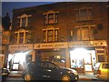
4
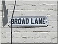
Old sign for Broad Lane (N15)
The location of this sign is shown in Image
Image: © Mike Quinn
Taken: 7 Jun 2017
0.04 miles
6
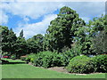
Gardens between Ashmount Road and Broad Lane, N15
Image: © Mike Quinn
Taken: 7 Jun 2017
0.05 miles
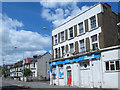
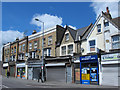
7
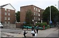
Broad lane / Wakefield Road, London N15
Image: © John Salmon
Taken: 18 Jul 2009
0.05 miles
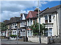
9
Broad Lane, N15 (3)
The north side, between Talbot Road and Hanover Road.
Image: © Mike Quinn
Taken: 7 Jun 2017
0.05 miles