IMAGES TAKEN NEAR TO
Philip Lane, LONDON, N15 4JL
Introduction
This page details the photographs taken nearby to Philip Lane, N15 4JL by members of the Geograph project.
The Geograph project started in 2005 with the aim of publishing, organising and preserving representative images for every square kilometre of Great Britain, Ireland and the Isle of Man.

There are currently over 7.5m images from over14,400 individuals and you can help contribute to the project by visiting https://www.geograph.org.uk
Image Map
Images are licensed for reuse under creativecommons.org/licenses/by-sa/2.0
Notes
- Clicking on the map will re-center to the selected point.
- The higher the marker number, the further away the image location is from the centre of the postcode.
Image Listing (64 Images Found)
Images are licensed for reuse under creativecommons.org/licenses/by-sa/2.0
Image
Details
Distance
1
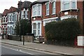
Houses on Philip Lane, South Tottenham
Image: © David Howard
Taken: 26 Jan 2022
0.02 miles


4
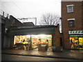
Greengrocers on West Green Road, South Tottenham
Image: © David Howard
Taken: 8 Dec 2016
0.05 miles
5
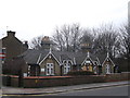
Josiah Forsters Almshouses, South Tottenham
Terrace of housing, on the junction of Winchelsea Road and Philip Lane (on the right).
This sheltered housing scheme consists of four terraced one-bedroom cottages for the elderly. It was establish in 1862 and modernised in 1986.
See http://en.wikipedia.org/wiki/Josiah_Forster for more about the teacher and philanthropist.
Image: © David Anstiss
Taken: 3 Feb 2013
0.05 miles
6

Forster Cottages, Philip Lane, South Tottenham (1860)
Image: © Jim Osley
Taken: 21 Jan 2011
0.06 miles
7
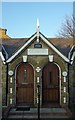
Double entrance with gable, Forster Cottages, Philip Lane, South Tottenham
With slab with the legend 18 J & R F 60 in relief.
Image: © Jim Osley
Taken: 21 Jan 2011
0.06 miles
8
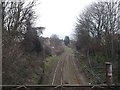
Railway to Bruce Grove
As seen from Philip Lane roadbridge.
This line leads from Seven Sisters.
Image: © David Anstiss
Taken: 3 Feb 2013
0.06 miles
9

Tottenham : Grace Baptist Chapel
"benezer Strict Baptist chapel, Napier Road, traced its origins to meetings held at Welbourne hall, near the high cross, in 1884. Worshippers moved to a site in the fork between Napier and Ranelagh roads, north of Philip Lane, in 1887. Ebenezer chapel, registered there in 1898, had Sunday attendances of 65 and 93 in 1903 and seating for 300 twenty-five years later. In 1972 it was a low yellow-brick building, with red-brick decoration." - https://www.british-history.ac.uk/vch/middx/vol5/pp356-364#p37
Image: © Jim Osley
Taken: 7 Aug 2019
0.07 miles
10
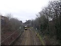
Railway to Seven Sisters
As seen from Philip Lane roadbridge.
This line leads from Bruce Grove.
The train passes under the Clyde Road.
Image: © David Anstiss
Taken: 3 Feb 2013
0.08 miles