IMAGES TAKEN NEAR TO
Philip Lane, LONDON, N15 4JA
Introduction
This page details the photographs taken nearby to Philip Lane, N15 4JA by members of the Geograph project.
The Geograph project started in 2005 with the aim of publishing, organising and preserving representative images for every square kilometre of Great Britain, Ireland and the Isle of Man.

There are currently over 7.5m images from over14,400 individuals and you can help contribute to the project by visiting https://www.geograph.org.uk
Image Map
Images are licensed for reuse under creativecommons.org/licenses/by-sa/2.0
Notes
- Clicking on the map will re-center to the selected point.
- The higher the marker number, the further away the image location is from the centre of the postcode.
Image Listing (98 Images Found)
Images are licensed for reuse under creativecommons.org/licenses/by-sa/2.0
Image
Details
Distance
1
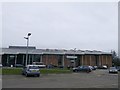
Tottenham Leisure Centre
On Town Hall Approach Road.
It is also used by Marcus Garvey Library.
Image: © David Anstiss
Taken: 3 Feb 2013
0.02 miles
3
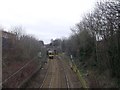
Railway to Seven Sisters
As seen from Philip Lane roadbridge.
This line leads from Bruce Grove.
The train passes under the Clyde Road.
Image: © David Anstiss
Taken: 3 Feb 2013
0.04 miles
4

Arnold Road at the junction of Philip Lane
Image: © David Howard
Taken: 23 Jan 2021
0.05 miles
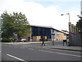
6
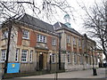
Hartsbrook Primary School, South Tottenham
Large grade II listed former college on Town Hall Approach Road.
See http://www.britishlistedbuildings.co.uk/en-201535-former-county-school-greater-london-auth for more details about the school.
Image: © David Anstiss
Taken: 3 Feb 2013
0.06 miles
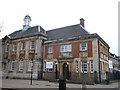
7
Former Tottenham County School building (1913)
Architect: H.G. Crothall. The school remained in this building until 1963.
Image: © Jim Osley
Taken: 3 Jun 2013
0.07 miles
8
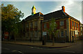
Clyde Road London N15 once prestigious house
This beautiful old property boasts marvellous octagonal windows, and architraves around the others. It is one of a pair of buildings in the area which have lost their gardens to housing and have been turned into flats which gives them a rather hemmed in appearance. The slate roof on this one looks like it is going to need some attendance.
Image: © John Kingdon
Taken: 21 Apr 2021
0.07 miles
9
Hartsbrook Primary School, South Tottenham
Large grade II listed former college on Town Hall Approach Road.
See http://www.britishlistedbuildings.co.uk/en-201535-former-county-school-greater-london-auth for more details about the school.
Image: © David Anstiss
Taken: 3 Feb 2013
0.07 miles
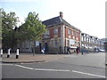
10
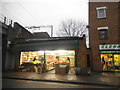
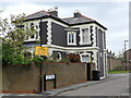
Greengrocers on West Green Road, South Tottenham
Image: © David Howard
Taken: 8 Dec 2016
0.08 miles