IMAGES TAKEN NEAR TO
Tynemouth Road, LONDON, N15 4AU
Introduction
This page details the photographs taken nearby to Tynemouth Road, N15 4AU by members of the Geograph project.
The Geograph project started in 2005 with the aim of publishing, organising and preserving representative images for every square kilometre of Great Britain, Ireland and the Isle of Man.

There are currently over 7.5m images from over14,400 individuals and you can help contribute to the project by visiting https://www.geograph.org.uk
Image Map
Images are licensed for reuse under creativecommons.org/licenses/by-sa/2.0
Notes
- Clicking on the map will re-center to the selected point.
- The higher the marker number, the further away the image location is from the centre of the postcode.
Image Listing (114 Images Found)
Images are licensed for reuse under creativecommons.org/licenses/by-sa/2.0
Image
Details
Distance
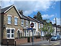
6
Springfield Road, N15
The lamppost is leaning! (So is the parking regulations pole.)
Image: © Mike Quinn
Taken: 7 Jun 2017
0.09 miles
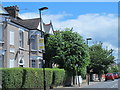
7
Antill Road, N15
The west side, south of Tynemouth Road. Just beyond the houses is the Image
Image: © Mike Quinn
Taken: 7 Jun 2017
0.09 miles
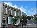
8

Victoria Line ventilation shaft, Tynemouth Road / Antill Road, N15
Image: © Mike Quinn
Taken: 7 Jun 2017
0.10 miles
9
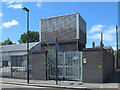
Victoria Line ventilation shaft, Tynemouth Road / Antill Road, N15 (2)
Image: © Mike Quinn
Taken: 7 Jun 2017
0.10 miles
10
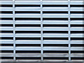
Victoria Line ventilation shaft, Tynemouth Road / Antill Road, N15 - detail
See Image
Image: © Mike Quinn
Taken: 7 Jun 2017
0.10 miles