IMAGES TAKEN NEAR TO
Carlingford Road, LONDON, N15 3EH
Introduction
This page details the photographs taken nearby to Carlingford Road, N15 3EH by members of the Geograph project.
The Geograph project started in 2005 with the aim of publishing, organising and preserving representative images for every square kilometre of Great Britain, Ireland and the Isle of Man.

There are currently over 7.5m images from over14,400 individuals and you can help contribute to the project by visiting https://www.geograph.org.uk
Image Map
Images are licensed for reuse under creativecommons.org/licenses/by-sa/2.0
Notes
- Clicking on the map will re-center to the selected point.
- The higher the marker number, the further away the image location is from the centre of the postcode.
Image Listing (166 Images Found)
Images are licensed for reuse under creativecommons.org/licenses/by-sa/2.0
Image
Details
Distance
5
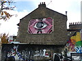
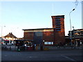
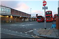
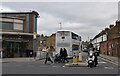
Wall Advertising Space Repurposed Near Turnpike Lane
The mural on the old advertising space looks a little tatty and the subject matter reminds me of 1970's sloganeering. The face within the star within the eyeball asking us to envision peace I imagine goes completely unnoticed. The graffiti art on the wall below has a date, 31.7.2022, but the 'Turnpike Art Group' board seems long abandoned.
Image: © John Kingdon
Taken: 9 Nov 2023
0.09 miles
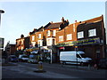
7
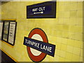
Signage, Turnpike Lane Underground Station
Image: © Robin Sones
Taken: 23 Nov 2010
0.10 miles
9
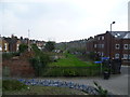
Looking along the line of the old Palace Gates to Seven Sisters railway line
The railway line between Seven Sisters and Palace Gates was opened by the Great Eastern Railway on 1st January 1878 and closed by British Railways to passengers on 7th January 1963 and completely on 5th October 1964. Apart from its route and some of the bridges, very little evidence that it ever existed remains.
This is the view from the bridge carrying Westbury Avenue over the line and looks in the direction of West Green station. The back of the houses in Mannock Road are to the left and those of Graham Road to the right.
A full account of the line with photographs can be seen at http://www.disused-stations.org.uk/w/west_green/index.shtml
Image: © Marathon
Taken: 8 Apr 2015
0.11 miles