IMAGES TAKEN NEAR TO
West Green Road, LONDON, N15 3DT
Introduction
This page details the photographs taken nearby to West Green Road, N15 3DT by members of the Geograph project.
The Geograph project started in 2005 with the aim of publishing, organising and preserving representative images for every square kilometre of Great Britain, Ireland and the Isle of Man.

There are currently over 7.5m images from over14,400 individuals and you can help contribute to the project by visiting https://www.geograph.org.uk
Image Map
Images are licensed for reuse under creativecommons.org/licenses/by-sa/2.0
Notes
- Clicking on the map will re-center to the selected point.
- The higher the marker number, the further away the image location is from the centre of the postcode.
Image Listing (182 Images Found)
Images are licensed for reuse under creativecommons.org/licenses/by-sa/2.0
Image
Details
Distance
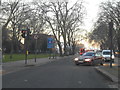
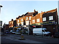
1
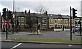
Green Lanes Harringay
Looking across at West Green Road from the A105
Image: © David Howard
Taken: 9 Mar 2010
0.03 miles
2
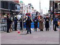
Salvation Army band, Wood Green, December 2011
Image: © Jim Osley
Taken: 11 Dec 2011
0.05 miles
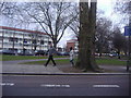
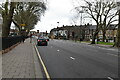
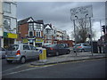
3
Flats on West Green Road
Near Milton Road.
Image: © Danny P Robinson
Taken: 21 Mar 2008
0.05 miles
6
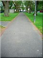
Ducketts Common cut through towards Green Gate Common
Ducketts Common cut through towards Green Gate Common. Often marked on maps as an extension of Hampden road.
Image: © fodc
Taken: 16 Jun 2012
0.06 miles
7
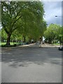
Ducketts Common towards Turnpike Lane
A view of Ducketts Common (left) and Green Lanes heading towards Turnpike Lane.
Image: © fodc
Taken: 16 Jun 2012
0.06 miles
9
Alfoxton Avenue Harringay
Junction with Green Lanes
Image: © David Howard
Taken: 9 Mar 2010
0.07 miles