IMAGES TAKEN NEAR TO
Etherley Road, LONDON, N15 3AT
Introduction
This page details the photographs taken nearby to Etherley Road, N15 3AT by members of the Geograph project.
The Geograph project started in 2005 with the aim of publishing, organising and preserving representative images for every square kilometre of Great Britain, Ireland and the Isle of Man.

There are currently over 7.5m images from over14,400 individuals and you can help contribute to the project by visiting https://www.geograph.org.uk
Image Map
Images are licensed for reuse under creativecommons.org/licenses/by-sa/2.0
Notes
- Clicking on the map will re-center to the selected point.
- The higher the marker number, the further away the image location is from the centre of the postcode.
Image Listing (78 Images Found)
Images are licensed for reuse under creativecommons.org/licenses/by-sa/2.0
Image
Details
Distance
1
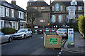
Etherley Road school street with Chestnuts Primary School
Image: © Tom Page
Taken: 17 Jan 2021
0.02 miles
3
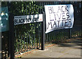
South Tottenham : road sign, Black Boy Lane
Image: © Jim Osley
Taken: 12 Jun 2020
0.08 miles
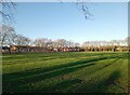
5
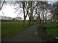
Chestnuts Park
Picture taken from the St Ann's Road / Black Boy Lane gate
Image: © Danny P Robinson
Taken: 24 Mar 2008
0.09 miles
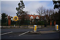
6
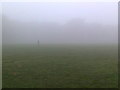
Chestnuts Park Autumn Mist
Trying to find the park cafe.
Image: © John Kingdon
Taken: 24 Sep 2013
0.09 miles
7
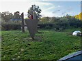
Small garden in Chestnuts Park, South Tottenham
A small area set aside for peaceful relaxation
Image: © David Howard
Taken: 3 Oct 2021
0.10 miles

9

Salvation Army Citadel, South Tottenham
Built 1908.
Image: © Jim Osley
Taken: 20 Dec 2013
0.11 miles
10
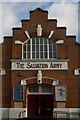
Salvation Army Citadel, South Tottenham
Built 1908.
Image: © Jim Osley
Taken: 20 Dec 2013
0.11 miles