IMAGES TAKEN NEAR TO
St. Peter's Way, LONDON, N1 4SG
Introduction
This page details the photographs taken nearby to St. Peter's Way, N1 4SG by members of the Geograph project.
The Geograph project started in 2005 with the aim of publishing, organising and preserving representative images for every square kilometre of Great Britain, Ireland and the Isle of Man.

There are currently over 7.5m images from over14,400 individuals and you can help contribute to the project by visiting https://www.geograph.org.uk
Image Map
Images are licensed for reuse under creativecommons.org/licenses/by-sa/2.0
Notes
- Clicking on the map will re-center to the selected point.
- The higher the marker number, the further away the image location is from the centre of the postcode.
Image Listing (232 Images Found)
Images are licensed for reuse under creativecommons.org/licenses/by-sa/2.0
Image
Details
Distance
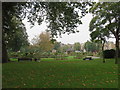
1
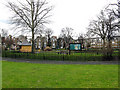
De Beauvoir Town: Looking across De Beauvoir Square
Direction of view, north west.
Image: © Dr Neil Clifton
Taken: 25 Feb 2010
0.02 miles
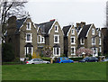
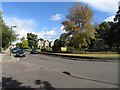
2
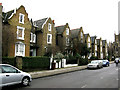
De Beauvoir Town: South side of De Beauvoir Square
This is a very attractive and select area of London, where traffic-calming measures have kept out rat runners. Many of the large houses are still in single-family occupation, and all are well-maintained and neat.
Image: © Dr Neil Clifton
Taken: 25 Feb 2010
0.03 miles
4
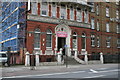
Kingsland Road: The Metropolitan Hospital
The Metropolitan Hospital, which had been founded in 1836 for homeless and destitute persons, moved to this building in 1885. The building became redundant in 1977 and is now occupied by commercial concerns.
Image: © Dr Neil Clifton
Taken: 9 Mar 2011
0.03 miles
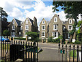
6
De Beauvoir Town, Hackney : north side, De Beauvoir Square
Grade II listed 19th century residences, north side, De Beauvoir Square. Description at this https://historicengland.org.uk/listing/the-list/list-entry/1226680.
Image: © Jim Osley
Taken: 13 Apr 2019
0.05 miles
7
De Beauvoir Square
Three sides of De Beauvoir Square consist of semi-detached 19th century Tudor villas. For the history of the development of the Square and the surrounding area see this http://www.british-history.ac.uk/report.aspx?compid=22699.
Image: © Jim Osley
Taken: 6 Jun 2014
0.05 miles
8
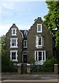
19th century Tudor villa, De Beauvoir Square
Grade II listed building, described at this http://list.english-heritage.org.uk/resultsingle.aspx?uid=1226680.
Image: © Jim Osley
Taken: 6 Jun 2014
0.05 miles
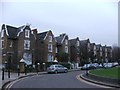
10
Houses on De Beauvoir Square
This square and its housing is the most substantial part of the grand design for De Beauvoir Town to have been completed.
As originally planned in the 1820s, the Town was to be a development of housing for the wealthy, laid out in a series of squares and avenues.
The scheme was never finished due to land ownership problems.
History on https://en.wikipedia.org/wiki/De_Beauvoir_Town
Image: © Des Blenkinsopp
Taken: 23 Jul 2016
0.05 miles