IMAGES TAKEN NEAR TO
Culford Grove, LONDON, N1 4HR
Introduction
This page details the photographs taken nearby to Culford Grove, N1 4HR by members of the Geograph project.
The Geograph project started in 2005 with the aim of publishing, organising and preserving representative images for every square kilometre of Great Britain, Ireland and the Isle of Man.

There are currently over 7.5m images from over14,400 individuals and you can help contribute to the project by visiting https://www.geograph.org.uk
Image Map
Images are licensed for reuse under creativecommons.org/licenses/by-sa/2.0
Notes
- Clicking on the map will re-center to the selected point.
- The higher the marker number, the further away the image location is from the centre of the postcode.
Image Listing (124 Images Found)
Images are licensed for reuse under creativecommons.org/licenses/by-sa/2.0
Image
Details
Distance
5
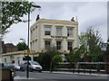
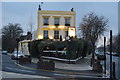
The Scolt Head, Kingsland
This pub, at the junction of Englefield Road, Culford Road and Ardleigh Road, was formerly called the Sussex Arms. It was renamed after the island on the Norfolk coast - apparently the owners' favourite place.
Image: © Stephen McKay
Taken: 1 May 2009
0.08 miles


9

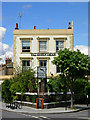
Englefield Road, Kingsland
Seen from close to the junction with Southgate Road.
Image: © Stephen McKay
Taken: 1 May 2009
0.09 miles