IMAGES TAKEN NEAR TO
Tottenham Road, LONDON, N1 4DY
Introduction
This page details the photographs taken nearby to Tottenham Road, N1 4DY by members of the Geograph project.
The Geograph project started in 2005 with the aim of publishing, organising and preserving representative images for every square kilometre of Great Britain, Ireland and the Isle of Man.

There are currently over 7.5m images from over14,400 individuals and you can help contribute to the project by visiting https://www.geograph.org.uk
Image Map
Images are licensed for reuse under creativecommons.org/licenses/by-sa/2.0
Notes
- Clicking on the map will re-center to the selected point.
- The higher the marker number, the further away the image location is from the centre of the postcode.
Image Listing (201 Images Found)
Images are licensed for reuse under creativecommons.org/licenses/by-sa/2.0
Image
Details
Distance
1
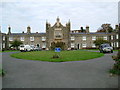
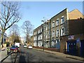
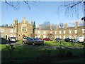
Alms Houses in Balls Pond Rd
These Metropolitan Benefit Society Alms Houses are in the Balls Pond Road. The society was founded in 1829.
Image: © Glyn Baker
Taken: 4 Oct 2005
0.04 miles
7
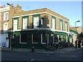
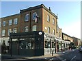
The Hunter S, Islington
Named after the writer Hunter S Thompson, it was formerly known as The Perseverance Tavern.
Image: © Chris Whippet
Taken: 8 Feb 2015
0.07 miles
8
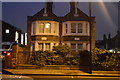
Almshouses, Balls Pond Road, Islington
Image: © Chris Whippet
Taken: 8 Feb 2015
0.07 miles
9
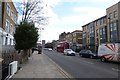
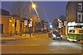
Along Balls Pond Road
A number 38 bus to Victoria approaches bus stop BH.
Image: © DS Pugh
Taken: 5 Apr 2016
0.07 miles