IMAGES TAKEN NEAR TO
Burder Close, LONDON, N1 4BA
Introduction
This page details the photographs taken nearby to Burder Close, N1 4BA by members of the Geograph project.
The Geograph project started in 2005 with the aim of publishing, organising and preserving representative images for every square kilometre of Great Britain, Ireland and the Isle of Man.

There are currently over 7.5m images from over14,400 individuals and you can help contribute to the project by visiting https://www.geograph.org.uk
Image Map (259 Images)


Getting Data...Please wait
Leaflet Map data © OpenStreetMap
Images are licensed for reuse under creativecommons.org/licenses/by-sa/2.0
Notes
- Clicking on the map will re-center to the selected point.
- The higher the marker number, the further away the image location is from the centre of the postcode.
Image Listing (259 Images Found)
Images are licensed for reuse under creativecommons.org/licenses/by-sa/2.0
Image
Details
Distance
1
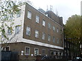
Kingsland Green Telephone Exchange (1)
Situated in Kingsland Green E8 2LA, this TE has the code CLKLG and serves Dalston, Kingsland, Shacklewell and Stoke Newington. It used to have CLIssold and SPArtan numbers until the late 1960s, but now has 0207-241, 249, 254 and 275 xxxx numbers, plus some Inner London numbers. This TE can be recognised by its BT warning notices and ventilation louvres on the ground floor.
Image: © David Hillas
Taken: 4 Nov 2011
0.05 miles
2
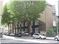
Kingsland Green Telephone Exchange (2)
This photo shows the TE in Kingsland Green E8 2LA, behind a group of plane trees which are a common sight in London's streets. To the right of the photo can be seen a jib on the roof below which there are a pair of doors where TE equipment is hoisted through them. A BT Openreach van can be seen in front of the TE, whilst a No Through Road sign is fixed on a lamp standard to the left of the photo.
Image: © David Hillas
Taken: 11 Oct 2011
0.05 miles
4
Platforms of Dalston Kingsland Station
Image: © Danny P Robinson
Taken: 9 Apr 2007
0.07 miles

6
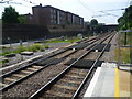
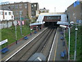
View from the platform at Dalston Kingsland station
A station was first opened on this site in 1850 by the North London Railway. It closed in 1865 when an extension was built to Broad Street in the City of London and a triangular junction was installed which joined the existing tracks to the east and west of the station. A new Dalston Junction station was opened at the southern tip of the junction and it replaced Kingsland station. The present Dalston Kingsland station was rebuilt and reopened on 16 May 1983 as part of the rejuvenated North London Line from Richmond to North Woolwich. It eventually replaced Dalston Junction when it closed in 1986, along with the rest of the line to Broad Street. Dalston Junction re-opened on 27 April 2010 on the London Overground East London Line extension.
This is the view from the end of the platform of Dalston Kingsland station looking towards Canonbury which is the next station. The curve from Dalston Junction can be seen coming in from the left, just this side of the high wall.
Image: © Marathon
Taken: 19 Jun 2013
0.07 miles
8
Dalston - Boleyn Road, looking north
Boleyn Road turns through 90 degrees at this junction.
Image: © Peter Whatley
Taken: 11 Apr 2011
0.08 miles
9
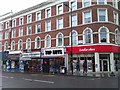
Kingsland High Street E8
From the junction with Boleyn Road
Image: © Robin Sones
Taken: 26 May 2012
0.08 miles
