IMAGES TAKEN NEAR TO
Kingsbury Road, LONDON, N1 4AZ
Introduction
This page details the photographs taken nearby to Kingsbury Road, N1 4AZ by members of the Geograph project.
The Geograph project started in 2005 with the aim of publishing, organising and preserving representative images for every square kilometre of Great Britain, Ireland and the Isle of Man.

There are currently over 7.5m images from over14,400 individuals and you can help contribute to the project by visiting https://www.geograph.org.uk
Image Map
Images are licensed for reuse under creativecommons.org/licenses/by-sa/2.0
Notes
- Clicking on the map will re-center to the selected point.
- The higher the marker number, the further away the image location is from the centre of the postcode.
Image Listing (258 Images Found)
Images are licensed for reuse under creativecommons.org/licenses/by-sa/2.0
Image
Details
Distance
2

St Judes Street Garden
This small play area and green space beyond is next to the London Overground line between Canonbury and Dalston Kingsland. The railway is just beyond the wall on the right.
Image: © Marathon
Taken: 19 Jun 2013
0.04 miles
6
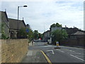
King Henry's Walk, London N1
Looking north east.
Image: © JThomas
Taken: 5 Aug 2017
0.05 miles
7
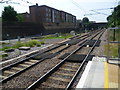
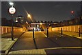
View from the platform at Dalston Kingsland station
A station was first opened on this site in 1850 by the North London Railway. It closed in 1865 when an extension was built to Broad Street in the City of London and a triangular junction was installed which joined the existing tracks to the east and west of the station. A new Dalston Junction station was opened at the southern tip of the junction and it replaced Kingsland station. The present Dalston Kingsland station was rebuilt and reopened on 16 May 1983 as part of the rejuvenated North London Line from Richmond to North Woolwich. It eventually replaced Dalston Junction when it closed in 1986, along with the rest of the line to Broad Street. Dalston Junction re-opened on 27 April 2010 on the London Overground East London Line extension.
This is the view from the end of the platform of Dalston Kingsland station looking towards Canonbury which is the next station. The curve from Dalston Junction can be seen coming in from the left, just this side of the high wall.
Image: © Marathon
Taken: 19 Jun 2013
0.05 miles
8

St Judes Street Garden
This small play area and green space beyond is next to the London Overground line between Canonbury and Dalston Kingsland. The railway is just beyond the wall on the right.
Image: © Marathon
Taken: 19 Jun 2013
0.05 miles
9
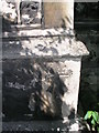
Cut bench mark on Islington, St Jude's church
See http://www.bench-marks.org.uk/bm43788 for details.
Image: © Brian Westlake
Taken: 26 May 2012
0.05 miles
10
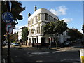
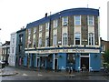
The 'Earl of Radnor', Dalston
This Victorian public house still appears to be open but a 'For Sale' notice affixed does not bode well for its future. Perhaps the recent slump in property prices will prolong its life for a year or two. It is at the junction of King Henry's Walk with Mildmay Grove South.
Image: © Dr Neil Clifton
Taken: 16 Oct 2008
0.06 miles