IMAGES TAKEN NEAR TO
Lincoln Avenue, LONDON, N14 7LG
Introduction
This page details the photographs taken nearby to Lincoln Avenue, N14 7LG by members of the Geograph project.
The Geograph project started in 2005 with the aim of publishing, organising and preserving representative images for every square kilometre of Great Britain, Ireland and the Isle of Man.

There are currently over 7.5m images from over14,400 individuals and you can help contribute to the project by visiting https://www.geograph.org.uk
Image Map
Images are licensed for reuse under creativecommons.org/licenses/by-sa/2.0
Notes
- Clicking on the map will re-center to the selected point.
- The higher the marker number, the further away the image location is from the centre of the postcode.
Image Listing (58 Images Found)
Images are licensed for reuse under creativecommons.org/licenses/by-sa/2.0
Image
Details
Distance
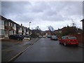
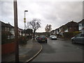
4
Hampden Way at the junction of Mandeville Road
Image: © David Howard
Taken: 18 Nov 2015
0.11 miles
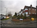
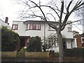
6
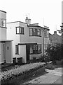
Modernist house, Whitehouse Way
One of a few 1930s houses in this road built in the moderne style, in various states of repair. There are further examples in nearby Abbotshall Avenue.
Image: © Jim Osley
Taken: 23 Jul 2014
0.12 miles
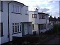
8
Art deco houses on Whitehouse Way, Southgate
Image: © David Howard
Taken: 18 Nov 2015
0.15 miles