IMAGES TAKEN NEAR TO
Langside Crescent, LONDON, N14 7DR
Introduction
This page details the photographs taken nearby to Langside Crescent, N14 7DR by members of the Geograph project.
The Geograph project started in 2005 with the aim of publishing, organising and preserving representative images for every square kilometre of Great Britain, Ireland and the Isle of Man.

There are currently over 7.5m images from over14,400 individuals and you can help contribute to the project by visiting https://www.geograph.org.uk
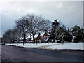
Image Map
Images are licensed for reuse under creativecommons.org/licenses/by-sa/2.0
Notes
- Clicking on the map will re-center to the selected point.
- The higher the marker number, the further away the image location is from the centre of the postcode.
Image Listing (255 Images Found)
Images are licensed for reuse under creativecommons.org/licenses/by-sa/2.0
Image
Details
Distance
1
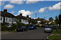
Suburban houses at the junction of Raith Avenue and Arnos Grove, N11
Image: © Christopher Hilton
Taken: 17 Aug 2017
0.10 miles
2
Semi-detached London: Arnos Grove, N11
Image: © Christopher Hilton
Taken: 17 Aug 2017
0.11 miles
3
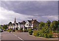
Minchenden Crescent, London N14
Minchenden Crescent just before crossroads with Arnos Grove. The spire of Christ Church can be seen.
Image: © Christine Matthews
Taken: 23 Aug 2008
0.13 miles
4
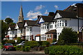
Semi-detached London: Minchenden Crescent, N11
The spire is that of Christchurch, Southgate, on Waterfall Road.
Image: © Christopher Hilton
Taken: 17 Aug 2017
0.13 miles
5

Entrance to Lulworth Court, Cannon Hill, London N14
Looking across Cannon Hill we have the small roadway which is the entrance to Lulworth Court. Lulworth Court is the Southern Wing of what used to be Arnos Grove, subsequently Southgate House while it was the offices of an insurance company and now divided into Lulworth Court residential flats in the southern wing and the Beaumont Nursing Home in the northern wing.
Image: © Christine Matthews
Taken: 1 Jul 2008
0.14 miles
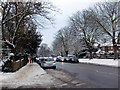
6
Cannon Hill, London N14
As seen from the east side.
Image: © Christine Matthews
Taken: 20 Dec 2010
0.14 miles

8
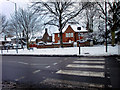
Zebra Crossing, Cannon Hill, London N14
This crossing is close to Cannon Road.
Image: © Christine Matthews
Taken: 20 Dec 2010
0.14 miles
9
Cannon Hill, London N14
Looking down Cannon Hill towards Aldermans Hill from the corner of Cannon Road.
Image: © Christine Matthews
Taken: 20 Dec 2010
0.14 miles
10
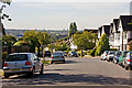
Arnos Grove
Looking across the valley carved by Pymmes Brook from the Southgate Village Green end of this street. The street is lined with semi-detached and terraced housing.
On the opposite side of the valley, the blue building half way up the hill on the left is a builders merchant, located beside the mainline on Station Road, New Southgate. The twin tower blocks on the horizon are on Prospect Ring in East Finchley.
Image: © Martin Addison
Taken: 25 Sep 2009
0.14 miles