IMAGES TAKEN NEAR TO
Ulleswater Road, LONDON, N14 7BT
Introduction
This page details the photographs taken nearby to Ulleswater Road, N14 7BT by members of the Geograph project.
The Geograph project started in 2005 with the aim of publishing, organising and preserving representative images for every square kilometre of Great Britain, Ireland and the Isle of Man.

There are currently over 7.5m images from over14,400 individuals and you can help contribute to the project by visiting https://www.geograph.org.uk
Image Map
Images are licensed for reuse under creativecommons.org/licenses/by-sa/2.0
Notes
- Clicking on the map will re-center to the selected point.
- The higher the marker number, the further away the image location is from the centre of the postcode.
Image Listing (15 Images Found)
Images are licensed for reuse under creativecommons.org/licenses/by-sa/2.0
Image
Details
Distance
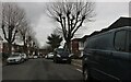
1
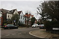
Ulleswater Road at the junction of Conway Road
A number of these links between main roads in the area have been blocked off with bollards.
Image: © David Howard
Taken: 4 Mar 2021
0.07 miles
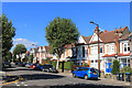
3

Corrib Court, Fox Lane, Palmers Green
An old school, now apartments.
Image: © Des Blenkinsopp
Taken: 25 Sep 2018
0.13 miles
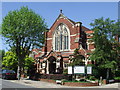
7

Palmers Green United Reformed Church
Entrance to the church hall.
Image: © Malc McDonald
Taken: 23 May 2010
0.19 miles
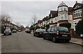
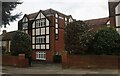
8
Palmers Green United Reformed Church
The United Reformed Church in Fox Lane, Palmers Green.
Image: © Malc McDonald
Taken: 23 May 2010
0.20 miles
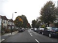
10
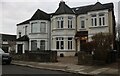
Victorian houses on Conway Road, Palmers Green
Image: © David Howard
Taken: 4 Mar 2021
0.22 miles