IMAGES TAKEN NEAR TO
Wynchgate, LONDON, N14 6RP
Introduction
This page details the photographs taken nearby to Wynchgate, N14 6RP by members of the Geograph project.
The Geograph project started in 2005 with the aim of publishing, organising and preserving representative images for every square kilometre of Great Britain, Ireland and the Isle of Man.

There are currently over 7.5m images from over14,400 individuals and you can help contribute to the project by visiting https://www.geograph.org.uk
Image Map
Images are licensed for reuse under creativecommons.org/licenses/by-sa/2.0
Notes
- Clicking on the map will re-center to the selected point.
- The higher the marker number, the further away the image location is from the centre of the postcode.
Image Listing (309 Images Found)
Images are licensed for reuse under creativecommons.org/licenses/by-sa/2.0
Image
Details
Distance
1
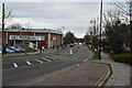
Wynchgate, London N14
Wynchgate as seen from the corner of Raleigh Way, looking towards Southgate.
Image: © Christine Matthews
Taken: 31 Aug 2008
0.04 miles
2
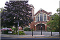
The Bourne Methodist Church, Southgate, London N14
The Bourne Methodist Church as seen from the entrance to the Priory Hospital
Image: © Christine Matthews
Taken: 31 Aug 2008
0.05 miles
3
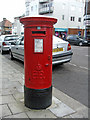
Edward VIII Pillar Box, Winchmore Hill Road, N14
This is one of the few larger size Edward VIII Pillar Boxes to have survived. Originally placed on the roundabout opposite the station, at some time it was moved to a safer position, probably when Southgate Circus as it is today was constructed. Image]
Image: © Christine Matthews
Taken: 21 Jan 2007
0.06 miles
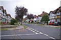
4
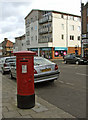
Winchmore Hill Road Southgate, N14, with Edward VIII Pillar Box
This image shows the Edward VIII Pillar Box in its surroundings in Winchmore Hill Road, Southgate.
Image: © Christine Matthews
Taken: 21 Jan 2007
0.06 miles
5
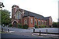
The Bourne Methodist Church, Southgate, London N14
The Bourne Methodist Church is on the corner of The Bourne and Queen Elizabeth Drive. This view is as seen from Wynchgate.
Image: © Christine Matthews
Taken: 31 Aug 2008
0.06 miles
6
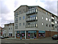
Apartment Block/Shops in Winchmore Hill Road, N14
This new development of apartments and shops is on the site of the old KwikFit Exhaust Centre / Petrol Station.
Image: © Christine Matthews
Taken: 21 Jan 2007
0.06 miles
7
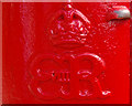
Royal Cypher, Edward VIII Pillar Box, Winchmore Hill Road, London N14
Edward VIII pillar boxes are quite rare, especially the larger size, which is what this is, but there are a number of them in the Southgate area, as a lot of development took place in the 1930s following the construction of the Piccadilly Line extension to Cockfosters.
Image: © Christine Matthews
Taken: 10 Oct 2009
0.06 miles
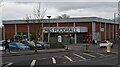
8
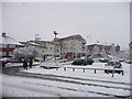
Marks and Spencer Food Store Car Park, London N14
Looking across the car park of the Marks and Spencer Food Store in Winchmore Hill road towards the new apartment block.
Image: © Christine Matthews
Taken: 6 Jan 2010
0.07 miles