IMAGES TAKEN NEAR TO
Oakfield Road, LONDON, N14 6LT
Introduction
This page details the photographs taken nearby to Oakfield Road, N14 6LT by members of the Geograph project.
The Geograph project started in 2005 with the aim of publishing, organising and preserving representative images for every square kilometre of Great Britain, Ireland and the Isle of Man.

There are currently over 7.5m images from over14,400 individuals and you can help contribute to the project by visiting https://www.geograph.org.uk
Image Map
Images are licensed for reuse under creativecommons.org/licenses/by-sa/2.0
Notes
- Clicking on the map will re-center to the selected point.
- The higher the marker number, the further away the image location is from the centre of the postcode.
Image Listing (79 Images Found)
Images are licensed for reuse under creativecommons.org/licenses/by-sa/2.0
Image
Details
Distance

2
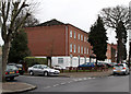
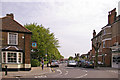
Modern Housing on The Mall
Modern apartment blocks on The Mall beside the junction with Oakfield Road.
Image: © Martin Addison
Taken: 12 Feb 2011
0.09 miles
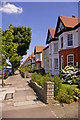
3

Oakfield Road from the corner of Norman Way
Image: © David Howard
Taken: 18 Apr 2013
0.09 miles
5
Old cattle pound
This is at the junction of Fox Lane and Bourne Hill. It has been restored, but it seems unlikely that it has been used recently.
Image: © Robin Webster
Taken: 3 Nov 2012
0.17 miles
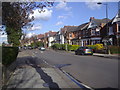
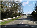
6
Pavement, Selborne Road, London N14
Looking up Selborne Road from near the Cannon Hill end, I liked the shapes of the red roofs of the houses contrasting with the blue sky.
Image: © Christine Matthews
Taken: 1 Jul 2008
0.17 miles
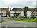
7
The Mall, Southgate, London N14
Looking down the Mall with Ye Olde Cherry Tree public house on the left.
Image: © Christine Matthews
Taken: 5 May 2008
0.18 miles
8
The Bourne, Southgate
The Bourne is the main A111 which can be seen here near the entrance to Grovelands Park via Inverforth Gate - see http://www.geograph.org.uk/photo/4839012
Image: © Marathon
Taken: 24 Feb 2016
0.18 miles
9
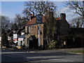
The Woodman, Palmers Green
Located on Bourne Hill opposite the junction with Fox Lane and close to the entrance to Grovelands Park, The Woodman was originally constructed as two cottages in 1727. It was licensed to sell ale in 1868.
Sources: https://whatpub.com/pubs/ENF/7352/woodman-palmers-green
http://www.palmersgreenn13.com/places-2/inns-and-pubs/old-stagers/
Image: © Paul Bryan
Taken: 1 Mar 2015
0.18 miles
10
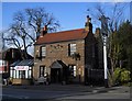
The Woodman, Palmers Green
Located on Bourne Hill opposite the junction with Fox Lane and close to the entrance to Grovelands Park, The Woodman was originally constructed as two cottages in 1727. It was licensed to sell ale in 1868.
Sources: https://whatpub.com/pubs/ENF/7352/woodman-palmers-green
http://www.palmersgreenn13.com/places-2/inns-and-pubs/old-stagers/
Image: © Paul Bryan
Taken: 1 Mar 2015
0.18 miles