IMAGES TAKEN NEAR TO
The Close, LONDON, N14 6DP
Introduction
This page details the photographs taken nearby to The Close, N14 6DP by members of the Geograph project.
The Geograph project started in 2005 with the aim of publishing, organising and preserving representative images for every square kilometre of Great Britain, Ireland and the Isle of Man.

There are currently over 7.5m images from over14,400 individuals and you can help contribute to the project by visiting https://www.geograph.org.uk
Image Map
Images are licensed for reuse under creativecommons.org/licenses/by-sa/2.0
Notes
- Clicking on the map will re-center to the selected point.
- The higher the marker number, the further away the image location is from the centre of the postcode.
Image Listing (251 Images Found)
Images are licensed for reuse under creativecommons.org/licenses/by-sa/2.0
Image
Details
Distance
1

Wall by the High Street, London N14
Image: © Christine Matthews
Taken: 24 Feb 2018
0.05 miles
2
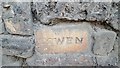
Wall by the High Street, London N14
Word on brickwork - COWEN.
Image: © Christine Matthews
Taken: 24 Feb 2018
0.05 miles
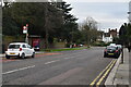
6
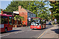
Passing W6's
Buses on the Edmonton Green to Southgate route pass on the High Street in Southgate. The trees are mainly still green, but occasionally there is a hint of autumn colour.
Image: © Martin Addison
Taken: 25 Sep 2009
0.08 miles
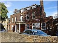
7
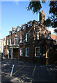
Southgate Masonic Centre
Located on the High Street, Southgate.
Image: © Martin Addison
Taken: 25 Sep 2009
0.09 miles
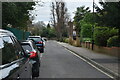
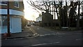
9
High Street, Southgate, London N14
The Grill Restaurant can be seen on the other side of the road.
Image: © Christine Matthews
Taken: 9 Feb 2012
0.09 miles
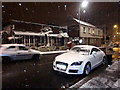
10
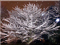
Winter Wonderland, London N14
Snow covered tree in open space Southgate High Street.
Image: © Christine Matthews
Taken: 9 Feb 2012
0.09 miles